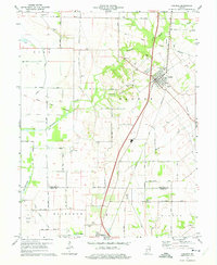
1974 Map of Carlisle
USGS Topo · Published 1975About this map
The town of Carlisle serves as a focal point in this southern Indiana landscape, where the Louisville and Nashville and Chicago and Eastern Illinois railroads intersect. A notable diagonal line across the terrain marks the Old Indian Treaty Boundary, illustrating how early land cessions permanently etched their path into the regional survey system. The area is dense with family and community burial grounds, including the Old Town Cem and Dooley Cem near the town center, and the IOOF Cem to the northwest.
Find a feature on this map
38 named features on this map. Tap any name to fly to it.
Don’t see what you’re looking for? This feature index may not catch every label — zoom into the map to look around manually.
Map Details
Editions of this 1974 Carlisle Map
2 editions found
Other maps of this area

1917 · Birds
USGS Topo · 1:62,500

1942 · Birds
USGS Topo · 1:62,500

1943 · Merom
USGS Topo · 1:24,000

1943 · Carlisle
USGS Topo · 1:24,000

1943 · Oaktown
USGS Topo · 1:24,000

1943 · Bicknell
USGS Topo · 1:24,000

1943 · Sullivan
USGS Topo · 1:24,000

1943 · Dugger
USGS Topo · 1:24,000

1944 · Bucktown
USGS Topo · 1:24,000
1952 · Dugger
USGS Topo · 1:24,000