1950s Maps of Sullivan County, Indiana
Explore 21 historic maps of Sullivan County from the 1950s. These maps offer a rare glimpse into what life looked like during the 1950s — showing old roads, neighborhoods, homes, and landmarks that have changed or disappeared over time.
Whether you're researching your family's past, planning a metal detecting trip, or studying how Sullivan County's landscape evolved across the 1950s, these high-resolution maps are a powerful tool for exploring the history of this region.
- Focus on a specific era: All maps on this page are from the 1950s, giving you a focused view of this time period.
- See what’s changed: Compare century-old streets, trails, and buildings to today's modern landscape using overlays and satellite layers.
- Research with precision: Use these maps for genealogy, historical research, land use analysis, or educational projects.
- View, download, or print: Maps are fully viewable online in high resolution, and can be downloaded or printed for your own records.
Start exploring Sullivan County's history through authentic maps from the 1950s. This is your window into the past.
Sullivan County, IN maps
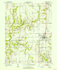
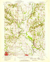
(21)- 1952 Map of Dugger, 1953 Print
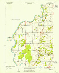
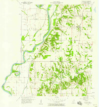
 1952 Dugger1953 Print · USGSSullivan County’s coal country is captured here in the early fifties as surface mining reshaped the Indiana landscape. Researchers can trace the industrial footprint of the Illinois Central railroad alongside local sites like Long Chapel and Woodward Cem.
 - 1952 Map of Lewis, 1953 Print
 1952 Lewis1953 Print · USGSVigo and Sullivan counties during the early fifties reveal a landscape transitioning from the canal era to an intensive mining economy. Genealogists and local historians can trace family roots through numerous landmarks like Fletcher Chapel, Stephens Cem, and the settlement of Lewis.2 unique versions available
 - 1952 Map of Fairbanks, 1953 Print
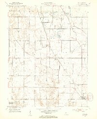
 1952 Fairbanks1953 Print · USGSSullivan County and the Wabash River bottomlands are captured here in the early fifties, showing a rural Indiana landscape of bluffs and bayous. Researchers can locate numerous family burial sites like Pound Cem and Riggs Cem or trace the historic Harrison Trail.2 unique versions available
 - 1952 Map of Shelburn, 1953 Print
 1952 Shelburn1953 Print · USGSSullivan County’s coal and rail landscape is captured here in the early fifties, centered on the corridor between Farmersburg and Shelburn. Genealogists and historians can trace numerous rural landmarks, including Little Flock Cem, Douglas Chapel Ch, and the workings of a local Strip Mine.2 unique versions available
 - 1952 Map of Hutton, 1953 Print
 1952 Hutton1953 Print · USGSVigo County and the Indiana-Illinois border are shown here during the early fifties, where the river-bound economy met burgeoning oil exploration. Genealogists can trace family footprints at Lykens Cem or locate the old Darwin Ferry crossing on the Wabash River.
 - 1953 Map of Hymera
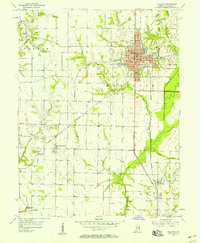
 1953 Hymera1953 Print · USGSMid-century Indiana coal country is mapped here in detail, showing a landscape defined by industrial extraction and small rail-side settlements. Genealogists and researchers can trace local family roots through sites like Sugar Grove Ch, Salem Cem, and Jackson Hill.
 - 1953 Map of Indianapolis, 1965 Print
 1953 Indianapolis1965 Print · USGSCentral Indiana and the Illinois borderlands are captured in the mid-sixties, showing the growth of Indianapolis and its industrial rail corridors. Genealogists and historians can trace the development of outlying towns like Zionsville or Beech Grove and find landmarks such as Atterbury AAF and Turkey Run State Park.4 unique versions available
 - 1956 Map of Indianapolis
 1956 Indianapolis1956 Print · USGSCentral Indiana in the mid-fifties is captured during a period of industrial growth and military presence. Genealogists and historians can trace the rail networks of the New York Central or locate regional landmarks like Fort Benjamin Harrison and Camp Atterbury.
 - 1956 Map of Sullivan, 1958 Print
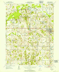
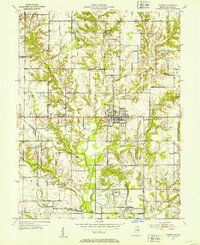
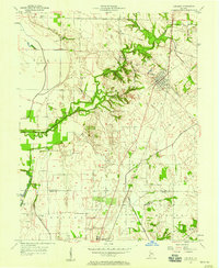
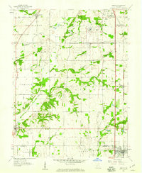
 1956 Sullivan1958 Print · USGSSullivan and its surrounding townships thrive as a rail and agricultural hub during the mid-fifties. Researchers can trace family history through numerous rural landmarks like Rose Chapel, Morgan Cem, and the small settlement of New Lebanon.
 - 1956 Map of Vincennes, 1967 Print
 1956 Vincennes1967 Print · USGSSouthern Indiana and the Illinois borderlands are captured here in the mid-fifties, showing the region's dense network of river towns and rail lines. Researchers can trace historic river crossings along the Wabash River or locate landmarks like Wyandotte Cave and Lincoln State Park.4 unique versions available
 - 1957 Map of Indianapolis
 1957 Indianapolis1957 Print · USGSCentral Indiana in the mid-fifties is captured here as a crossroads of major rail lines and nascent federal highways. Genealogists and historians can trace family-named ridges like Poplar Ridge or locate strategic sites like Camp Atterbury and Speedway.2 unique versions available
 - 1957 Map of Vincennes
 1957 Vincennes1957 Print · USGSSouthwest Indiana and the Illinois borderlands come alive in the late 1950s, a period of heavy rail traffic and expanding state forests. Genealogists and historians can trace the riverfronts and rail lines of Vincennes, New Harmony, and the vast Crane Naval Ammunition Depot.
 - 1957 Map of Bucktown, 1958 Print
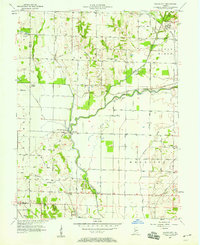
 1957 Bucktown1958 Print · USGSSoutheastern Sullivan County and northern Knox County appear here in the early 1940s as a landscape of rural homesteads and emerging coal works. Genealogists and historians can trace numerous family-named sites, including Benefiell Cem, Bethany Ch, and early Strip Mine operations.4 unique versions available
 - 1957 Map of Hutsonville, 1958 Print
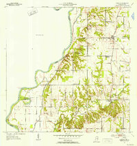
 1957 Hutsonville1958 Print · USGSThe Wabash River valley in the late fifties shows a landscape defined by river-and-rail commerce between Illinois and Indiana. Trace family roots at the Merom Institute or locate early landmarks like Dodds Bridge and the Hutsonville Bridge.2 unique versions available
 - 1957 Map of Carlisle, 1958 Print
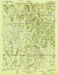
 1957 Carlisle1958 Print · USGSMid-century Sullivan and Knox counties are captured here as agriculture and energy infrastructure shape the land. Genealogists can locate numerous burial sites like Odd Fellows Cem and Ledgerwood Cem near the Vincennes Tract Boundary.
 - 1957 Map of Merom, 1958 Print
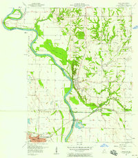 1957 Merom1958 Print · USGSThe Wabash River borderlands of Indiana and Illinois come alive in this mid-century study of the river's winding course. Researchers can locate family landmarks like the Old French Cem, the Merom Institute, and the Hutsonville Bridge (Toll).
 - 1957 Map of Saline City, 1958 Print
 1957 Saline City1958 Print · USGSClay County's rural and industrial character is preserved here in the late fifties, showing the area's transition through mining and rail transport. Researchers can trace the MONON rail lines, locate the Neal Mill Bridge, and find family sites like Stagg Cem or Briley Chapel.4 unique versions available
 - 1957 Map of Fairbanks, 1958 Print
 1957 Fairbanks1958 Print · USGSSullivan County and its Illinois neighbors appear during the late fifties as the Wabash River valley supported a dense network of riverfront farms and rural parishes. Researchers can locate family-named landmarks like Pogue Cem, the crossing at Dodds Bridge, and historic Indian Mounds near the water.
 - 1958 Map of Vincennes
 1958 Vincennes1958 Print · USGSSouthern Indiana and the Illinois borderlands are captured during a mid-century period of heavy rail traffic and military activity. Researchers can trace the sprawling bounds of the Crane Naval Ammunition Depot or locate historic settlements like New Harmony and French Lick.2 unique versions available
 - 1958 Map of Sandborn, 1959 Print
 1958 Sandborn1959 Print · USGSThe Knox and Greene county borderlands come into focus in the late fifties, showing a rural landscape shaped by the White River and a network of drainage ditches. Researchers can trace historic family locations at Sandborn Cem and Marco, or locate the path of the Indian Treaty Boundary.2 unique versions available
 - 1958 Map of Pimento, 1959 Print
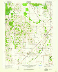
 1958 Pimento1959 Print · USGSThe rural border of Vigo and Sullivan counties is captured here in the late fifties, defined by its small farming towns and institutional landmarks. Researchers can trace family roots at New Harmony Cem or follow the Chicago and Eastern Illinois rail line through Pimento and Farmersburg.3 unique versions available
End of results
Showing maps 1-21 of 21
Top cities of Sullivan County
- Sullivan historical maps
- Cass historical maps
- Shelburn historical maps
- Farmersburg historical maps
- Dugger historical maps
- Hymera historical maps
See more
Frequently asked questions
- What are the different types of historical maps available for Sullivan County?
- What is the oldest map of Sullivan County?
- Where can I purchase historical maps of Sullivan County for my home or office?
- Where can I download high-res historical maps of Sullivan County?
- Are there historical topographic maps available for Sullivan County?
- Is there historical aerial imagery available for Sullivan County?
- Where are historical maps of Sullivan County sourced from?