1940s Maps of Switzerland County, Indiana
Explore 7 historic maps of Switzerland County from the 1940s. These maps offer a rare glimpse into what life looked like during the 1940s — showing old roads, neighborhoods, homes, and landmarks that have changed or disappeared over time.
Whether you're researching your family's past, planning a metal detecting trip, or studying how Switzerland County's landscape evolved across the 1940s, these high-resolution maps are a powerful tool for exploring the history of this region.
- Focus on a specific era: All maps on this page are from the 1940s, giving you a focused view of this time period.
- See what’s changed: Compare century-old streets, trails, and buildings to today's modern landscape using overlays and satellite layers.
- Research with precision: Use these maps for genealogy, historical research, land use analysis, or educational projects.
- View, download, or print: Maps are fully viewable online in high resolution, and can be downloaded or printed for your own records.
Start exploring Switzerland County's history through authentic maps from the 1940s. This is your window into the past.
Switzerland County, IN maps
(7)- 1943 Map of Florence
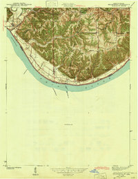
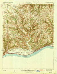 1943 Florence1943 Print · USGSSwitzerland County's rugged riverfront is captured here in the early 1940s, showing the steep ridges and hollows overlooking the Ohio River. Genealogists can locate family landmarks like Bark Works Cem, the Warsaw Ferry crossing, and local schools such as Phillips Sch and West Union Sch.
 - 1943 Map of Aberdeen
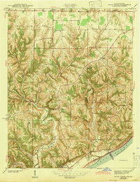
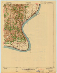
 1943 Aberdeen1943 Print · USGSSoutheastern Indiana's river hills are captured here just before mid-century, showing a landscape of ridge-top farms and creek-side settlements. Researchers can locate family landmarks like Gillespie Cem, Bascom Corner, and several schools including Fisher Sch.2 unique versions available
 - 1943 Map of Vevay North
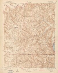
 1943 Vevay North1943 Print · USGSSoutheast Indiana during the early years of the war shows a landscape of ridge-top farms and river valley settlements. Genealogists can trace family footprints through numerous rural landmarks like Mt Sterling, Stow Cem, and Jacksonville Sch.2 unique versions available
 - 1943 Map of Rising Sun
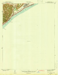
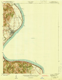 1943 Rising Sun1943 Print · USGSThe Ohio River valley in the early 1940s was a landscape defined by riverside settlements and the steady work of river navigation. Genealogists can trace family histories through local landmarks like German Cem, North Landing, and the Laughery Club.
 - 1943 Map of Brooksburg
 1943 Brooksburg1943 Print · USGSJefferson and Switzerland counties meet along the Ohio River in this early 1940s survey of the Indiana-Kentucky border. Trace the river-based economy and rural transit of the era through the Carrollton Ferry and family landmarks like Mc Kay Cem and McKay Sch.
 - 1943 Map of Patriot
 1943 Patriot1943 Print · USGSThe river town of Patriot and the winding Indiana shoreline appear here as they were in the early 1940s. Genealogists can trace family names through several rural landmarks, including Mc Nutt Cem, Wigal Cem, and Concord Ch.
 - 1943 Map of Vevay South
 1943 Vevay South1943 Print · USGSThe Indiana side of the Ohio River is captured in the early 1940s, showing the riverside town of Vevay and its surrounding hills. Genealogists can trace family landmarks like Potato Bug Hill, the Bridge Sch, and the County Infirmary.
End of results
Showing maps 1-7 of 7
Top cities of Switzerland County
Frequently asked questions
- What are the different types of historical maps available for Switzerland County?
- What is the oldest map of Switzerland County?
- Where can I purchase historical maps of Switzerland County for my home or office?
- Where can I download high-res historical maps of Switzerland County?
- Are there historical topographic maps available for Switzerland County?
- Is there historical aerial imagery available for Switzerland County?
- Where are historical maps of Switzerland County sourced from?