1980s Maps of Switzerland County, Indiana
Explore 4 historic maps of Switzerland County from the 1980s. These maps offer a rare glimpse into what life looked like during the 1980s — showing old roads, neighborhoods, homes, and landmarks that have changed or disappeared over time.
Whether you're researching your family's past, planning a metal detecting trip, or studying how Switzerland County's landscape evolved across the 1980s, these high-resolution maps are a powerful tool for exploring the history of this region.
- Focus on a specific era: All maps on this page are from the 1980s, giving you a focused view of this time period.
- See what’s changed: Compare century-old streets, trails, and buildings to today's modern landscape using overlays and satellite layers.
- Research with precision: Use these maps for genealogy, historical research, land use analysis, or educational projects.
- View, download, or print: Maps are fully viewable online in high resolution, and can be downloaded or printed for your own records.
Start exploring Switzerland County's history through authentic maps from the 1980s. This is your window into the past.
Switzerland County, IN maps
(4)- 1981 Map of Patriot, 1982 Print
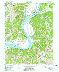 1981 Patriot1982 Print · USGSThe Ohio River valley in the early eighties serves as a backdrop for the riverside community of Patriot and the fertile farmsteads of the bottomlands. Researchers can trace ancestral roots through dozens of local sites like McNutt Cem, Concord Ch, and the outlying settlement at Searcy Crossroads.2 unique versions available
 - 1981 Map of Rising Sun, 1982 Print
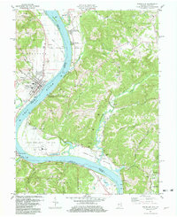 1981 Rising Sun1982 Print · USGSThe Ohio River valley between Indiana and Kentucky comes to life in this early 1980s record of rural river life and industry. Genealogists can trace deep local roots at Rabbit Hash and Rising Sun, or locate family sites like Stephens Cem and Rice Cem.3 unique versions available
 - 1986 Map of Madison
 1986 Madison1986 Print · USGSSouthern Indiana and Northern Kentucky are shown here in the mid-eighties, centered on the river corridor and the sprawling Jefferson Proving Ground. Genealogists and historians can trace rail lines like the Seaboard System and locate river towns from Madison to Bethlehem.
 - 1986 Map of Falmouth
 1986 Falmouth1986 Print · USGSNorthern Kentucky and the Ohio River valley are shown here in the mid-1980s, highlighting the region's complex river-and-rail geography. Genealogists and researchers can trace the roads connecting Big Bone Lick, Zion Church, and river towns like Falmouth and Augusta.2 unique versions available
End of results
Showing maps 1-4 of 4
Top cities of Switzerland County
Frequently asked questions
- What are the different types of historical maps available for Switzerland County?
- What is the oldest map of Switzerland County?
- Where can I purchase historical maps of Switzerland County for my home or office?
- Where can I download high-res historical maps of Switzerland County?
- Are there historical topographic maps available for Switzerland County?
- Is there historical aerial imagery available for Switzerland County?
- Where are historical maps of Switzerland County sourced from?