1940s Maps of Terre Haute, Indiana
Explore 3 historic maps of Terre Haute from the 1940s. These maps offer a rare glimpse into what life looked like during the 1940s — showing old roads, neighborhoods, homes, and landmarks that have changed or disappeared over time.
Whether you're researching your family's past, planning a metal detecting trip, or studying how Terre Haute's landscape evolved across the 1940s, these high-resolution maps are a powerful tool for exploring the history of this region.
- Focus on a specific era: All maps on this page are from the 1940s, giving you a focused view of this time period.
- See what’s changed: Compare century-old streets, trails, and buildings to today's modern landscape using overlays and satellite layers.
- Research with precision: Use these maps for genealogy, historical research, land use analysis, or educational projects.
- View, download, or print: Maps are fully viewable online in high resolution, and can be downloaded or printed for your own records.
Start exploring Terre Haute's history through authentic maps from the 1940s. This is your window into the past.
Terre Haute, IN maps
(3)- 1941 Map of Seelyville
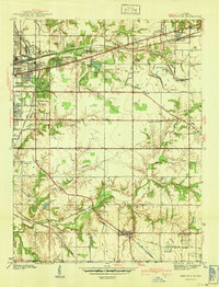 1941 Seelyville1941 Print · USGSVigo County at the start of the 1940s shows the industrial expansion of Terre Haute toward Seelyville. Trace family roots at Highland Lawn Cemetery or locate old industrial sites like the Binkley Mine and the Central Canal (Abandoned).2 unique versions available
 - 1941 Map of Terre Haute
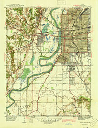 1941 Terre Haute1941 Print · USGSTerre Haute and the Wabash River valley are shown in high detail just before the mid-century industrial boom. Genealogists and local historians can trace family roots through dozens of named sites like Toad Hop, Woodlawn Cemetery, and Gerstmeyer High School.
 - 1948 Map of Terre Haute
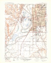 1948 Terre Haute1948 Print · USGSTerre Haute and its riverfront neighborhoods are shown here in the late 1940s, just as the regional rail and coal economy reached its peak. Researchers can trace the dense urban grid of schools and churches, find the old Duane Yards, or locate the site of Toad Hop across the Wabash River.2 unique versions available
End of results
Showing maps 1-3 of 3
Top cities near Terre Haute
- Clinton historical maps
- West Terre Haute historical maps
- Fairview Park historical maps
- Prairieton historical maps
- Prairie Creek historical maps
- Farmersburg historical maps
See more
Top neighborhoods of Terre Haute
- Deming Park historical maps
- Deming Woods historical maps
- Twelve Points historical maps
- Duane Yards historical maps
- Dewey historical maps
- Preston historical maps
See more
Frequently asked questions
- What are the different types of historical maps available for Terre Haute?
- What is the oldest map of Terre Haute?
- Where can I purchase historical maps of Terre Haute for my home or office?
- Where can I download high-res historical maps of Terre Haute?
- Are there historical topographic maps available for Terre Haute?
- Is there historical aerial imagery available for Terre Haute?
- Where are historical maps of Terre Haute sourced from?