1980s Maps of Terre Haute, Indiana
Explore 3 historic maps of Terre Haute from the 1980s. These maps offer a rare glimpse into what life looked like during the 1980s — showing old roads, neighborhoods, homes, and landmarks that have changed or disappeared over time.
Whether you're researching your family's past, planning a metal detecting trip, or studying how Terre Haute's landscape evolved across the 1980s, these high-resolution maps are a powerful tool for exploring the history of this region.
- Focus on a specific era: All maps on this page are from the 1980s, giving you a focused view of this time period.
- See what’s changed: Compare century-old streets, trails, and buildings to today's modern landscape using overlays and satellite layers.
- Research with precision: Use these maps for genealogy, historical research, land use analysis, or educational projects.
- View, download, or print: Maps are fully viewable online in high resolution, and can be downloaded or printed for your own records.
Start exploring Terre Haute's history through authentic maps from the 1980s. This is your window into the past.
Terre Haute, IN maps
(3)- 1986 Map of Paris
 1986 Paris1986 Print · USGSThe Illinois-Indiana borderlands thrive in the mid-1980s as a hub of river-side industry and fertile farmland. Genealogists and historians can trace rail-centered settlements like Chrisman and Metcalf, or locate family sites at the Quaker Cem and Bethel Ch.2 unique versions available
 - 1986 Map of Terre Haute
 1986 Terre Haute1986 Print · USGSThe Wabash River valley and the coal-rich hills of West-Central Indiana and East-Central Illinois are shown here in the mid-eighties. Genealogists and local historians can trace family-named corners like Barrick Corner, find rural churches like New Hope Ch, and locate industrial landmarks such as the Thunderbird Mine.2 unique versions available
 - 1986 Map of Terre Haute, 1989 Print
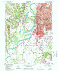 1986 Terre Haute1989 Print · USGSTerre Haute and its riverfront neighborhoods are shown here in the mid-eighties, balancing industrial infrastructure with a dense network of local schools and colleges. Researchers can trace historic routes like the Wabash and Erie Canal or locate family landmarks such as Durham Cem and Toad Hop.
End of results
Showing maps 1-3 of 3
Top cities near Terre Haute
- Clinton historical maps
- West Terre Haute historical maps
- Fairview Park historical maps
- Prairieton historical maps
- Prairie Creek historical maps
- Farmersburg historical maps
See more
Top neighborhoods of Terre Haute
- Deming Park historical maps
- Deming Woods historical maps
- Twelve Points historical maps
- Duane Yards historical maps
- Dewey historical maps
- Preston historical maps
See more
Frequently asked questions
- What are the different types of historical maps available for Terre Haute?
- What is the oldest map of Terre Haute?
- Where can I purchase historical maps of Terre Haute for my home or office?
- Where can I download high-res historical maps of Terre Haute?
- Are there historical topographic maps available for Terre Haute?
- Is there historical aerial imagery available for Terre Haute?
- Where are historical maps of Terre Haute sourced from?