1960s Maps of Wabash County, Indiana
Explore 12 historic maps of Wabash County from the 1960s. These maps offer a rare glimpse into what life looked like during the 1960s — showing old roads, neighborhoods, homes, and landmarks that have changed or disappeared over time.
Whether you're researching your family's past, planning a metal detecting trip, or studying how Wabash County's landscape evolved across the 1960s, these high-resolution maps are a powerful tool for exploring the history of this region.
- Focus on a specific era: All maps on this page are from the 1960s, giving you a focused view of this time period.
- See what’s changed: Compare century-old streets, trails, and buildings to today's modern landscape using overlays and satellite layers.
- Research with precision: Use these maps for genealogy, historical research, land use analysis, or educational projects.
- View, download, or print: Maps are fully viewable online in high resolution, and can be downloaded or printed for your own records.
Start exploring Wabash County's history through authentic maps from the 1960s. This is your window into the past.
Wabash County, IN maps
(12)- 1961 Map of Silver Lake, 1963 Print
 1961 Silver Lake1963 Print · USGSThe lake country of Kosciusko County comes into focus in the early sixties, showing the intersection of rural agriculture and rail-side industry. Genealogists can trace family roots through sites like Graceland Cem, Silver Creek Ch, and the small settlement of Disko.2 unique versions available
 - 1961 Map of Roann, 1963 Print
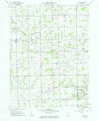
 1961 Roann1963 Print · USGSIndiana's Eel River valley comes alive in this early 1960s survey of Wabash and Miami counties. Genealogists and local historians can trace family ties at the Abshire Cem, locate the historic Covered Bridge at Roann, or explore the rail corridors of the Erie-Lackawanna.3 unique versions available
 - 1961 Map of Servia, 1963 Print
 1961 Servia1963 Print · USGSWabash and Huntington Counties are captured here in the early sixties, showing a landscape of small farms and crossroads communities. Researchers can locate family landmarks such as Stockert Cem, Servia Landing Field, and the Erie-Lackawanna rail line.3 unique versions available
 - 1961 Map of North Manchester South, 1963 Print
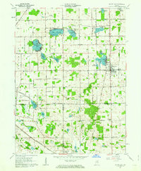
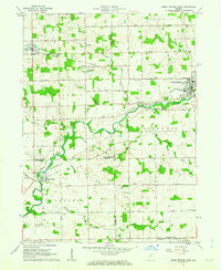
 1961 North Manchester South1963 Print · USGSWabash County's agricultural heartland was deeply connected by rail and river in the early 1960s. Genealogists can locate ancestral homesteads near Pleasant Hill Cem & Ch, Laketon, and the quiet crossroads of Ijamsville and Bolivar.3 unique versions available
 - 1962 Map of North Manchester North, 1963 Print
 1962 North Manchester North1963 Print · USGSKosciusko and Wabash counties are captured here in the early sixties, showing the rural grid and rail towns of northern Indiana. Genealogists can trace family sites at Rose Hill Cem, West Eel River Ch, and the grounds of Manchester College.2 unique versions available
 - 1962 Map of South Whitley West, 1963 Print
 1962 South Whitley West1963 Print · USGSIndiana's Eel River valley comes into sharp focus during the early sixties as a thriving corridor of rail and river commerce. Genealogists and historians can trace the foundations of South Whitley, explore the grounds of Township Sch, or locate family plots in Glenwood Cem and Union Cem.2 unique versions available
 - 1963 Map of Richvalley, 1964 Print
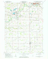
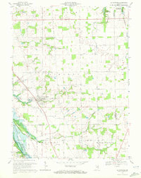
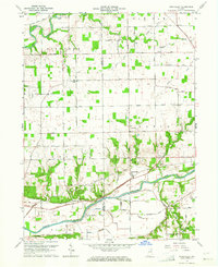 1963 Richvalley1964 Print · USGSRichvalley and the Wabash River corridor are captured here in the early sixties, showing the intersection of heavy rail and river valley life. Researchers can locate the Francis Godfroy Cem, trace the Wabash Railroad, and find early family sites along Carr Road.3 unique versions available
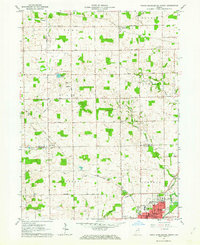
 - 1963 Map of Wabash, 1964 Print
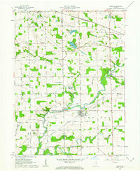
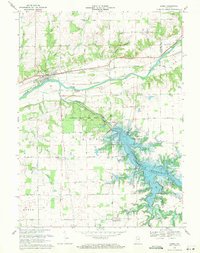
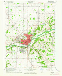 1963 Wabash1964 Print · USGSWabash and its surrounding townships are shown here during a period of post-war growth along the Wabash River. Researchers can trace old family sites across Speicherville, locate rural landmarks like Bachelor Creek Ch, or find historic burials at Falls Cem and Hebrew Cem.3 unique versions available
 - 1969 Map of Somerset, 1971 Print
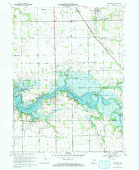 1969 Somerset1971 Print · USGSThe Wabash County countryside was being transformed by the rising Mississinewa Reservoir in the late sixties. Genealogists and local historians can trace the foundations of Somerset, locate the White Institute, and identify rural landmarks like Lebanon Ch and Treaty.3 unique versions available
 - 1969 Map of Peoria, 1971 Print
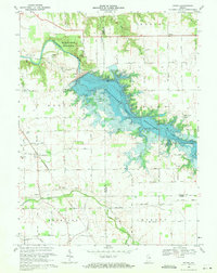 1969 Peoria1971 Print · USGSNear the end of the 1960s, this portion of Indiana saw its river valleys reshaped by the rising Mississinewa Reservoir. Genealogists can locate family landmarks like Slocum Cem and Township Sch alongside the rail lines of the Chesapeake and Ohio.3 unique versions available
 - 1969 Map of Lagro, 1971 Print
 1969 Lagro1971 Print · USGSWabash and Huntington counties meet here in the late sixties, where the rising waters of the Salamonie Reservoir reshape the valley. Genealogists can locate family landmarks like St Patricks Cem, Hopewell Ch, and the settlement of Lincolnville.3 unique versions available
 - 1969 Map of La Fontaine, 1972 Print
 1969 La Fontaine1972 Print · USGSThe rural borderlands of Wabash and Grant counties are captured here in the late sixties as modern reservoirs began to shape the landscape. Local historians can trace family plots at Boundary Line Cem and Gardner Cem or follow the path of the Penn Central through La Fontaine.2 unique versions available
End of results
Showing maps 1-12 of 12
Top cities of Wabash County
- Wabash historical maps
- North Manchester historical maps
- La Fontaine historical maps
- Lagro historical maps
- Roann historical maps
- Liberty Mills historical maps
Frequently asked questions
- What are the different types of historical maps available for Wabash County?
- What is the oldest map of Wabash County?
- Where can I purchase historical maps of Wabash County for my home or office?
- Where can I download high-res historical maps of Wabash County?
- Are there historical topographic maps available for Wabash County?
- Is there historical aerial imagery available for Wabash County?
- Where are historical maps of Wabash County sourced from?