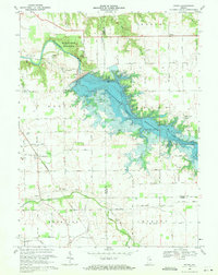
1969 Map of Peoria
USGS Topo · Published 1971About this map
Mississinewa Reservoir dominates this landscape on the border of Miami and Wabash Counties, reflecting a period of significant hydrological change in northern Indiana. The reservoir, noted here at its normal pool elevation of 737, transformed the valley of the Mississinewa River, creating extensive recreational zones like the Frances Slocum State Recreation Area and Miami State Recreation Area. Despite these modern developments, the map preserves the traditional rural fabric of the region, including the small settlements of Peoria and New Santa Fe.
Find a feature on this map
46 named features on this map. Tap any name to fly to it.
Don’t see what you’re looking for? This feature index may not catch every label — zoom into the map to look around manually.
Map Details
Editions of this 1969 Peoria Map
3 editions found
Other maps of this area

1951 · Peru
USGS Topo · 1:24,000

1951 · Bunker Hill
USGS Topo · 1:24,000

1951 · Richvalley
USGS Topo · 1:24,000

1952 · Wabash
USGS Topo · 1:24,000

1953 · Somerset
USGS Topo · 1:24,000

1953 · Peoria
USGS Topo · 1:24,000

1953 · Danville
USGS Topo · 1:250,000

1953 · Muncie
USGS Topo · 1:250,000

1955 · Danville
USGS Topo · 1:250,000

1956 · Muncie
USGS Topo · 1:250,000