1900s (20th Century) Maps of Reynolds, Indiana
Explore 8 historic maps of Reynolds from the 1900s (20th Century). These maps offer a rare glimpse into what life looked like during the 1900s — showing old roads, neighborhoods, homes, and landmarks that have changed or disappeared over time.
Whether you're researching your family's past, planning a metal detecting trip, or studying how Reynolds's landscape evolved across the 1900s, these high-resolution maps are a powerful tool for exploring the history of this region.
- Focus on a specific era: All maps on this page are from the 1900s, giving you a focused view of this time period.
- See what’s changed: Compare century-old streets, trails, and buildings to today's modern landscape using overlays and satellite layers.
- Research with precision: Use these maps for genealogy, historical research, land use analysis, or educational projects.
- View, download, or print: Maps are fully viewable online in high resolution, and can be downloaded or printed for your own records.
Start exploring Reynolds's history through authentic maps from the 1900s. This is your window into the past.
Reynolds, IN maps
(8)- 1953 Map of Danville, 1965 Print
 1953 Danville1965 Print · USGSIndiana and Illinois crossroads come to life in this mid-century survey as the interstate era begins to reshape the river-and-rail landscape. Genealogists and collectors can trace the historic paths of the Nickel Plate railroad or locate smaller communities like Veedersburg, Goodland, and Bismarck.3 unique versions available
 - 1955 Map of Danville
 1955 Danville1955 Print · USGSThe Indiana-Illinois borderlands during the mid-fifties reveal a landscape of thriving rail hubs and university towns. Researchers can trace the legacy of Purdue University, the Tippecanoe Battlefield, and the path of the Pennsylvania RR.
 - 1956 Map of Danville
 1956 Danville1956 Print · USGSMid-century Indiana and Illinois are captured here as the river-and-rail economy evolved into the modern highway era. Researchers can trace ancestral roots and old transport lines through Logansport, Battle Ground, and the dams at Lake Shafer.
 - 1962 Map of Monticello South, 1963 Print
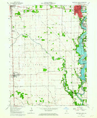 1962 Monticello South1963 Print · USGSWhite County enters a new era of lakeside living in the early sixties as development spreads along the shores of Lake Freeman. Researchers can trace the civic growth of Monticello or locate family roots at Bunnell Cem and the small whistle-stop of Smithson.2 unique versions available
 - 1962 Map of Brookston NW, 1963 Print
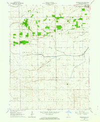 1962 Brookston NW1963 Print · USGSWhite County’s agricultural landscape is seen here in the early sixties, highlighting the vital drainage infrastructure of the Indiana prairie. Researchers can trace rural cemetery locations like West Point Cem and the settlement at Reynolds alongside family-named projects like Bell Ditch.3 unique versions available
 - 1962 Map of Monon, 1964 Print
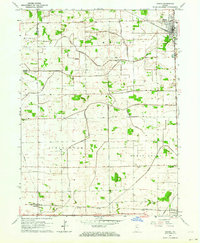 1962 Monon1964 Print · USGSWhite County's agricultural and rail heartland is captured here in the early sixties, showing the intersection of major Indiana transit lines. Genealogists can locate family sites at Palestine Cem and Swisher Cem or trace the rural rail stops of Seafield and Reynolds.2 unique versions available
 - 1962 Map of Monticello North, 1964 Print
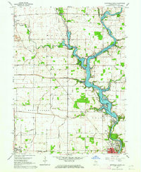 1962 Monticello North1964 Print · USGSWhite County was a hub of river activity and rail transport in the early sixties as leisure life expanded along the water. Genealogists can trace family roots through rural landmarks like Wilson Cem, Bedford Ch, and the vanished Twp Sch.2 unique versions available
 - 1985 Map of Logansport
 1985 Logansport1985 Print · USGSNorth-central Indiana in the mid-eighties shows a landscape of river-fed towns and significant military aviation hubs. Genealogists and local historians can trace the rail corridors of the Conrail or locate sites like River View Cem and the crossroads at Twelve Mile.2 unique versions available
End of results
Showing maps 1-8 of 8
Top cities near Reynolds
- Monticello historical maps
- Delphi historical maps
- Monon historical maps
- Brookston historical maps
- Wolcott historical maps
- Chalmers historical maps
See more
Frequently asked questions
- What are the different types of historical maps available for Reynolds?
- What is the oldest map of Reynolds?
- Where can I purchase historical maps of Reynolds for my home or office?
- Where can I download high-res historical maps of Reynolds?
- Are there historical topographic maps available for Reynolds?
- Is there historical aerial imagery available for Reynolds?
- Where are historical maps of Reynolds sourced from?