1980s Maps of Sharon, Iowa
Explore 2 historic maps of Sharon from the 1980s. These maps offer a rare glimpse into what life looked like during the 1980s — showing old roads, neighborhoods, homes, and landmarks that have changed or disappeared over time.
Whether you're researching your family's past, planning a metal detecting trip, or studying how Sharon's landscape evolved across the 1980s, these high-resolution maps are a powerful tool for exploring the history of this region.
- Focus on a specific era: All maps on this page are from the 1980s, giving you a focused view of this time period.
- See what’s changed: Compare century-old streets, trails, and buildings to today's modern landscape using overlays and satellite layers.
- Research with precision: Use these maps for genealogy, historical research, land use analysis, or educational projects.
- View, download, or print: Maps are fully viewable online in high resolution, and can be downloaded or printed for your own records.
Start exploring Sharon's history through authentic maps from the 1980s. This is your window into the past.
Sharon, IA maps
(2)- 1983 Map of Audubon, 1984 Print
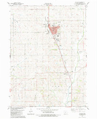 1983 Audubon1984 Print · USGSAudubon and the surrounding prairie townships are captured here in the early eighties as the community balanced its civic core with its river-valley agriculture. You can trace the locations of family burial grounds at Aretas Lodge Cemetery and Danish Cemetery, or locate the Courthouse and County Fairgrounds.
 - 1984 Map of Guthrie Center, 1985 Print
 1984 Guthrie Center1985 Print · USGSWest-central Iowa's river valleys and farming townships are shown here in the mid-1980s, highlighting a network of conservation areas and historic rail towns. Genealogists and local historians can locate Violet Hill Cem, trace the Chicago and North Western railroad, or explore the grounds of Springbrook State Park.
End of results
Showing maps 1-2 of 2
Top cities near Sharon
- Audubon historical maps
- Manning historical maps
- Anita historical maps
- Exira historical maps
- Walnut historical maps
- Elk Horn historical maps
See more
Frequently asked questions
- What are the different types of historical maps available for Sharon?
- What is the oldest map of Sharon?
- Where can I purchase historical maps of Sharon for my home or office?
- Where can I download high-res historical maps of Sharon?
- Are there historical topographic maps available for Sharon?
- Is there historical aerial imagery available for Sharon?
- Where are historical maps of Sharon sourced from?