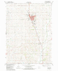
1983 Map of Audubon
USGS Topo · Published 1984About this map
Audubon serves as the focal point of this west-central Iowa survey, positioned where the valley of Bluegrass Creek meets the undulating landscape of Leroy and Douglas townships. The town plan is anchored by the Courthouse and essential civic landmarks including the County Memorial Hospital, the Armory, and the County Fairgrounds. This early 1980s data illustrates a well-developed regional infrastructure, with the Municipal Airport located south of the main settlement and several community spaces like Hahn Park and the Greenbrier Country Club.
Find a feature on this map
28 named features on this map. Tap any name to fly to it.
Don’t see what you’re looking for? This feature index may not catch every label — zoom into the map to look around manually.
Map Details
Editions of this 1983 Audubon Map
This is the sole edition of this map. No revisions or reprints were ever made.
Other maps of this area

1954 · Omaha
USGS Topo · 1:250,000

1957 · Omaha
USGS Topo · 1:250,000

1957 · Audubon
USGS Topo · 1:62,500

1958 · Omaha
USGS Topo · 1:250,000

1971 · Viola Center
USGS Topo · 1:24,000

1971 · Gray
USGS Topo · 1:24,000

1978 · Elk Horn
USGS Topo · 1:24,000

1978 · Kimballton
USGS Topo · 1:24,000
1978 · Manning SE
USGS Topo · 1:24,000
1980 · Harlan
USGS Topo · 1:100,000