1970s Maps of Benton County, Iowa
Explore 11 historic maps of Benton County from the 1970s. These maps offer a rare glimpse into what life looked like during the 1970s — showing old roads, neighborhoods, homes, and landmarks that have changed or disappeared over time.
Whether you're researching your family's past, planning a metal detecting trip, or studying how Benton County's landscape evolved across the 1970s, these high-resolution maps are a powerful tool for exploring the history of this region.
- Focus on a specific era: All maps on this page are from the 1970s, giving you a focused view of this time period.
- See what’s changed: Compare century-old streets, trails, and buildings to today's modern landscape using overlays and satellite layers.
- Research with precision: Use these maps for genealogy, historical research, land use analysis, or educational projects.
- View, download, or print: Maps are fully viewable online in high resolution, and can be downloaded or printed for your own records.
Start exploring Benton County's history through authentic maps from the 1970s. This is your window into the past.
Benton County, IA maps
(11)- 1971 Map of Elberon, 1973 Print
 1971 Elberon1973 Print · USGSElberon and the surrounding farmlands of Tama and Benton counties appear here in the early 1970s. Genealogists and local historians can locate several family burial sites like Houghton Cem and Toogood Cem near the Chicago Milwaukee St Paul and Pacific rail line.
 - 1971 Map of Van Horne, 1973 Print
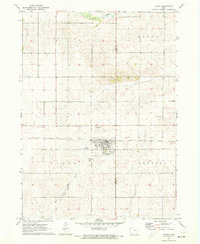
 1971 Van Horne1973 Print · USGSBenton County farm country is captured here in the early 1970s, centered on the railroad town of Van Horne. Genealogists and historians can trace the sections of Big Grove and Eldorado townships, locating Big Grove Cem and the rural Townhall.
 - 1971 Map of Dysart, 1973 Print
 1971 Dysart1973 Print · USGSThe agricultural community of Dysart sits at the heart of this early 1970s landscape on the Tama and Benton county line. Researchers can trace the path of the Chicago Rock Island and Pacific railroad or locate family burials at Ramthun Cem and St Joseph Cem.
 - 1971 Map of La Porte City, 1973 Print
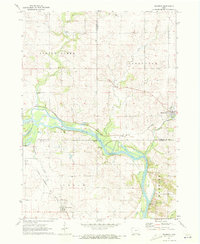
 1971 La Porte City1973 Print · USGSThe Cedar River valley in the early seventies shows a landscape defined by rail transport and river recreation. Researchers can trace family history through several rural burial sites, including Westview Cemetery, Antioch Cem, and the tracks of the Chicago Rock Island and Pacific railroad.
 - 1971 Map of Vinton, 1973 Print
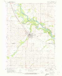
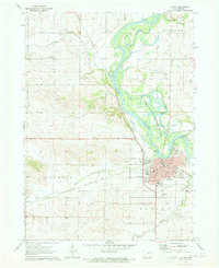 1971 Vinton1973 Print · USGSVinton thrives along the Cedar River in the early 1970s, defined by its rail connections and significant local institutions. Genealogists and historians can locate the Iowa Braille & Sightsaving Sch, the Fairground, and several family burial sites like Evergreen Cem.
 - 1971 Map of Brandon, 1973 Print
 1971 Brandon1973 Print · USGSThe Cedar River valley near the tri-county junction of Black Hawk, Buchanan, and Benton is captured here in the early 1970s. Trace the rural landscape through landmarks like Spring Creek Cem, the Fish Farm, and the Mt Auburn Bridge.2 unique versions available
 - 1971 Map of Garrison, 1973 Print
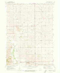
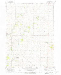
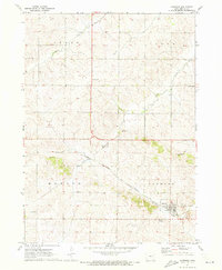 1971 Garrison1973 Print · USGSBenton County agriculture and rail transport intersect in the early 1970s, centered on the community of Garrison. Researchers can locate family landmarks like Gnagy Cem, the Pratt Creek Ch, and the route of the CHICAGO ROCK ISLAND AND PACIFIC railroad.
 - 1971 Map of Keystone North, 1973 Print
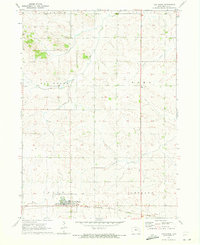
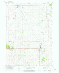
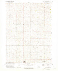 1971 Keystone North1973 Print · USGSBenton County farmland in the early seventies centers on the rail-side community of Keystone and its surrounding townships. Genealogists and local historians can trace rural landmarks and family burial sites like La Rue Cem and Bender Cem along the banks of Mud Creek.
 - 1973 Map of Cheney, 1977 Print
 1973 Cheney1977 Print · USGSThe rural borderlands of Buchanan and Benton Counties are captured here in the early 1970s, showcasing a landscape of winding creeks and section-line roads. Researchers can trace local history through the Townhall, Bear Creek Cemetery, and the settlement of Brandon.
 - 1973 Map of Walker, 1977 Print
 1973 Walker1977 Print · USGSEastern Iowa farmland is captured here in the early 1970s, spanning the border of Buchanan and Linn counties. Researchers can trace the Chicago Rock Island and Pacific rail line between Rowley and Walker, locating landmarks like Sacred Heart Cem and Spencers Grove.2 unique versions available
 - 1976 Map of Dubuque
 1976 Dubuque1976 Print · USGSThe tri-state borderlands of Iowa, Wisconsin, and Illinois come alive during the mid-seventies, showing a region built on river commerce and mining. Genealogists and historians can trace the paths of the Illinois Central railroad or locate heritage sites like the New Melleray Abbey Monastery and Backbone State Park.
End of results
Showing maps 1-11 of 11
Top cities of Benton County
- Vinton historical maps
- Belle Plaine historical maps
- Atkins historical maps
- Urbana historical maps
- Shellsburg historical maps
- Newhall historical maps
See more
Frequently asked questions
- What are the different types of historical maps available for Benton County?
- What is the oldest map of Benton County?
- Where can I purchase historical maps of Benton County for my home or office?
- Where can I download high-res historical maps of Benton County?
- Are there historical topographic maps available for Benton County?
- Is there historical aerial imagery available for Benton County?
- Where are historical maps of Benton County sourced from?