1900s (20th Century) Maps of Shellsburg, Iowa
Explore 9 historic maps of Shellsburg from the 1900s (20th Century). These maps offer a rare glimpse into what life looked like during the 1900s — showing old roads, neighborhoods, homes, and landmarks that have changed or disappeared over time.
Whether you're researching your family's past, planning a metal detecting trip, or studying how Shellsburg's landscape evolved across the 1900s, these high-resolution maps are a powerful tool for exploring the history of this region.
- Focus on a specific era: All maps on this page are from the 1900s, giving you a focused view of this time period.
- See what’s changed: Compare century-old streets, trails, and buildings to today's modern landscape using overlays and satellite layers.
- Research with precision: Use these maps for genealogy, historical research, land use analysis, or educational projects.
- View, download, or print: Maps are fully viewable online in high resolution, and can be downloaded or printed for your own records.
Start exploring Shellsburg's history through authentic maps from the 1900s. This is your window into the past.
Shellsburg, IA maps
(9)- 1903 Map of Winthrop
 1903 Winthrop1903 Print · USGSEast Central Iowa was a landscape of thriving rail towns and river crossings at the turn of the century. Genealogists and historians can trace the early footprints of Independence and Marion, or locate smaller centers like Quasqueton and Toddville.2 unique versions available
 - 1959 Map of Dubuque, 1982 Print
 1959 Dubuque1982 Print · USGSThe Tri-State region comes alive in the mid-twentieth century as a hub of river commerce and rail transit. Genealogists and historians can trace the paths of the Illinois Central Gulf through Dubuque or locate the Savanna Ordnance Depot and Lock and Dam No 11.
 - 1961 Map of Dubuque
 1961 Dubuque1961 Print · USGSThe Tri-State region's river-and-rail landscape is captured here during the early sixties, showing the convergence of Iowa, Illinois, and Wisconsin. Trace mid-century rail lines like the Chicago Great Western Ry and explore sites like the Savanna Ordnance Depot and Backbone State Park.
 - 1962 Map of Dubuque
 1962 Dubuque1962 Print · USGSThe Tri-State region's river-and-rail economy is captured here in the early sixties, centered on the Mississippi River bluffs. Genealogists and historians can locate Numerous lead and zinc mines, the New Melleray Abbey Monastery, and rural hubs like Saint Olaf.2 unique versions available
 - 1968 Map of Shellsburg, 1971 Print
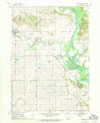 1968 Shellsburg1971 Print · USGSThe Cedar River valley in the late sixties reveals a landscape of river-town commerce and rail connectivity. Genealogists can locate Strawn Cem, Lincoln Ch, and Spring Grove Cem alongside the Chicago Rock Island and Pacific line.3 unique versions available
 - 1968 Map of Center Point SW, 1971 Print
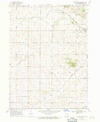 1968 Center Point SW1971 Print · USGSBenton County farm country remains defined by its creeks and rail lines during the late sixties. Researchers can trace family roots through several rural landmarks, including the First Eden Cem, the Parkers Grove Ch, and the streets of Shellsburg.
 - 1976 Map of Dubuque
 1976 Dubuque1976 Print · USGSThe tri-state borderlands of Iowa, Wisconsin, and Illinois come alive during the mid-seventies, showing a region built on river commerce and mining. Genealogists and historians can trace the paths of the Illinois Central railroad or locate heritage sites like the New Melleray Abbey Monastery and Backbone State Park.
 - 1984 Map of Anamosa, 1985 Print
 1984 Anamosa1985 Print · USGSEastern Iowa's river valleys and farming communities are captured here in the mid-eighties, showing a landscape defined by the Wapsipinicon River and Maquoketa River. Genealogists and historians can locate legacy landmarks like the Independence State Hospital, Ebys Mill, and the State Penal Farm.2 unique versions available
 - 1993 Map of Shellsburg, 1994 Print
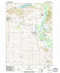 1993 Shellsburg1994 Print · USGSThe Cedar River valley in the early nineties shows a landscape where industrial energy and conservation meet. You can trace family roots at Strawn Cem or Old Palo Cem, and locate the Duane Arnold Energy Center near the village of Palo.
End of results
Showing maps 1-9 of 9
Top cities near Shellsburg
- Cedar Rapids historical maps
- Hiawatha historical maps
- Vinton historical maps
- Robins historical maps
- Fairfax historical maps
- Center Point historical maps
See more
Frequently asked questions
- What are the different types of historical maps available for Shellsburg?
- What is the oldest map of Shellsburg?
- Where can I purchase historical maps of Shellsburg for my home or office?
- Where can I download high-res historical maps of Shellsburg?
- Are there historical topographic maps available for Shellsburg?
- Is there historical aerial imagery available for Shellsburg?
- Where are historical maps of Shellsburg sourced from?