1960s Maps of Boone County, Iowa
Explore 9 historic maps of Boone County from the 1960s. These maps offer a rare glimpse into what life looked like during the 1960s — showing old roads, neighborhoods, homes, and landmarks that have changed or disappeared over time.
Whether you're researching your family's past, planning a metal detecting trip, or studying how Boone County's landscape evolved across the 1960s, these high-resolution maps are a powerful tool for exploring the history of this region.
- Focus on a specific era: All maps on this page are from the 1960s, giving you a focused view of this time period.
- See what’s changed: Compare century-old streets, trails, and buildings to today's modern landscape using overlays and satellite layers.
- Research with precision: Use these maps for genealogy, historical research, land use analysis, or educational projects.
- View, download, or print: Maps are fully viewable online in high resolution, and can be downloaded or printed for your own records.
Start exploring Boone County's history through authentic maps from the 1960s. This is your window into the past.
Boone County, IA maps
(9)- 1965 Map of Granger, 1966 Print
 1965 Granger1966 Print · USGSThe Des Moines River valley in the mid-sixties reveals a landscape undergoing transformation as the Saylorville Reservoir takes shape. Genealogists can locate family sites like Granger Homesteads or rural landmarks such as Hopkins Grove Cem and the Chestnut Ford Bridge.2 unique versions available
 - 1965 Map of Mackey, 1966 Print
 1965 Mackey1966 Print · USGSBoone and Hamilton counties are shown in the mid-1960s as a landscape of rural schoolhouses and family burial grounds. Researchers can trace local lineage at South Marion Cem and Leininger Cem or locate the old St Paul Sch and Mackey.
 - 1965 Map of Fraser, 1966 Print
 1965 Fraser1966 Print · USGSThe Des Moines River valley in the mid-1960s reveals a rural landscape transitioning toward major hydrological management. Researchers can trace ancestral locations at Hardin Cem or Mineral Ridge Cem and locate vanished landmarks near Ridgeport and Fraser.
 - 1965 Map of Woodward, 1966 Print
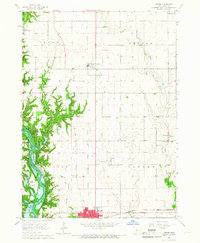
 1965 Woodward1966 Print · USGSThe Dallas County prairie in the mid-1960s is defined by its small towns and the sprawling Woodward State Hospital campus. Genealogists and local historians can trace the early reaches of Saylorville Reservoir and locate several rural burial grounds like Xenia and Greenwood Cemetery.
 - 1965 Map of Boone East, 1966 Print
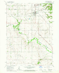
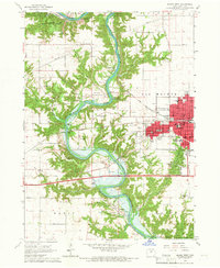
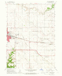 1965 Boone East1966 Print · USGSBoone and its surrounding townships show a robust rail and agricultural network in the mid-sixties. Genealogists and local historians can trace the paths of the Chicago and North Western or locate the Squire Boone Cem and Lowell Sch.2 unique versions available
 - 1965 Map of Boone West, 1966 Print
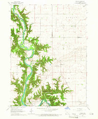
 1965 Boone West1966 Print · USGSThe Des Moines River valley in the mid-1960s shows a landscape of deep ravines, active mining, and new water management. Trace local history through Moingona, Battin Chapel, and the vanished Mine Dump sites near Logansport.2 unique versions available
 - 1965 Map of Madrid NW, 1967 Print
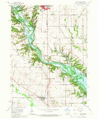
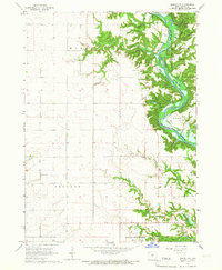 1965 Madrid NW1967 Print · USGSBoone County river life is captured here in the mid-sixties, just as the valley prepared for the waters of the Saylorville Reservoir. Genealogists and hikers can trace old landmarks like Peoples Cem, the Hubby Bridge, and the ridges of Ledges State Park.2 unique versions available
 - 1965 Map of Luther, 1967 Print
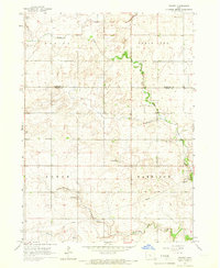
 1965 Luther1967 Print · USGSMid-century Boone County is captured here during a period of agricultural expansion and new water management projects. Genealogists and local historians can trace rural roots through landmarks like Garden Prairie Ch and the many family plots at Dalander Cem or Fairview Cem.2 unique versions available
 - 1969 Map of Des Moines
 1969 Des Moines1969 Print · USGSCentral Iowa's fertile plains and growing capital are captured here during the late sixties, a time of major highway expansion and reservoir construction. Genealogists and researchers can trace rural township boundaries, local cemeteries, and rail lines serving towns like Pella, Grinnell, and Oskaloosa.
End of results
Showing maps 1-9 of 9
Top cities of Boone County
- Boone historical maps
- Madrid historical maps
- Ogden historical maps
- Luther historical maps
- Fraser historical maps
- Berkley historical maps
Frequently asked questions
- What are the different types of historical maps available for Boone County?
- What is the oldest map of Boone County?
- Where can I purchase historical maps of Boone County for my home or office?
- Where can I download high-res historical maps of Boone County?
- Are there historical topographic maps available for Boone County?
- Is there historical aerial imagery available for Boone County?
- Where are historical maps of Boone County sourced from?