1980s Maps of Buchanan County, Iowa
Explore 8 historic maps of Buchanan County from the 1980s. These maps offer a rare glimpse into what life looked like during the 1980s — showing old roads, neighborhoods, homes, and landmarks that have changed or disappeared over time.
Whether you're researching your family's past, planning a metal detecting trip, or studying how Buchanan County's landscape evolved across the 1980s, these high-resolution maps are a powerful tool for exploring the history of this region.
- Focus on a specific era: All maps on this page are from the 1980s, giving you a focused view of this time period.
- See what’s changed: Compare century-old streets, trails, and buildings to today's modern landscape using overlays and satellite layers.
- Research with precision: Use these maps for genealogy, historical research, land use analysis, or educational projects.
- View, download, or print: Maps are fully viewable online in high resolution, and can be downloaded or printed for your own records.
Start exploring Buchanan County's history through authentic maps from the 1980s. This is your window into the past.
Buchanan County, IA maps
(8)- 1981 Map of Stanley, 1982 Print
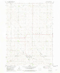 1981 Stanley1982 Print · USGSThe rural borderlands of Buchanan and Fayette Counties are captured here in the early eighties, centered on the village of Stanley. Local historians can trace family roots through the Stanley Cem, Garden Prairie Ch, and the path of the Chicago and North Western railroad.
 - 1981 Map of Hazleton, 1982 Print
 1981 Hazleton1982 Print · USGSBuchanan County in the early eighties preserves a landscape of traditional township schools and riverfront hamlets. Genealogists and local historians can trace family sites at North Amish Cem, follow the Old Railroad Grade through Bryantsburg, or locate the many local schoolhouses like Hickory Grove Sch.
 - 1981 Map of Oelwein, 1982 Print
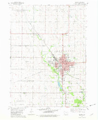 1981 Oelwein1982 Print · USGSThe rail-centered hub of Oelwein and the rural borderlands of Fayette and Buchanan Counties are captured here in the early 1980s. Researchers can locate vanished landmarks like the Drive-in Theater or trace family plots at Woodlawn Cem and Otsego Cem.
 - 1981 Map of Oelwein SE, 1982 Print
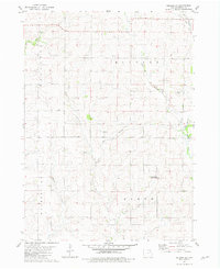 1981 Oelwein SE1982 Print · USGSNorthern Buchanan County farmland is captured here in the early eighties, showing the quiet rural intersections of four distinct townships. Researchers can trace local landmarks like Spangler Cem, the small settlement of Fenner, and the Van Laningham County Wildlife Area.
 - 1984 Map of Oelwein, 1985 Print
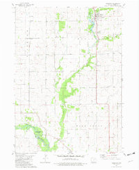
 1984 Oelwein1985 Print · USGSNortheast Iowa and the Mississippi riverfront appear in detail during the 1980s, showing a land defined by deep river valleys and high ridges. Genealogists and historians can trace the Chicago and North Western rail line and locate rural sites like St Sebald Ch and Quaker Mill Pond.2 unique versions available
 - 1984 Map of Marshalltown, 1985 Print
 1984 Marshalltown1985 Print · USGSMid-Iowa's agricultural landscape and river corridors come alive in the mid-eighties as the Cedar River connects industrial hubs and small farm towns. Trace the tracks of the CHICAGO AND NORTHWESTERN or locate local landmarks like Union Grove State Park and Cedar Falls Junction.2 unique versions available
 - 1984 Map of Waverly, 1985 Print
 1984 Waverly1985 Print · USGSNortheast Iowa in the mid-eighties shows a robust network of river towns and rail corridors connecting agricultural centers. Researchers can trace family sites near Garden of Memories Cem or follow the Chicago and North Western line through Janesville and Waverly.2 unique versions available
 - 1984 Map of Anamosa, 1985 Print
 1984 Anamosa1985 Print · USGSEastern Iowa's river valleys and farming communities are captured here in the mid-eighties, showing a landscape defined by the Wapsipinicon River and Maquoketa River. Genealogists and historians can locate legacy landmarks like the Independence State Hospital, Ebys Mill, and the State Penal Farm.2 unique versions available
End of results
Showing maps 1-8 of 8
Top cities of Buchanan County
- Independence historical maps
- Jesup historical maps
- Winthrop historical maps
- Hazleton historical maps
- Quasqueton historical maps
- Lamont historical maps
See more
Frequently asked questions
- What are the different types of historical maps available for Buchanan County?
- What is the oldest map of Buchanan County?
- Where can I purchase historical maps of Buchanan County for my home or office?
- Where can I download high-res historical maps of Buchanan County?
- Are there historical topographic maps available for Buchanan County?
- Is there historical aerial imagery available for Buchanan County?
- Where are historical maps of Buchanan County sourced from?