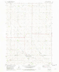
1981 Map of Stanley
USGS Topo · Published 1982About this map
Stanley sits at the intersection of rural life and transit in this northern Buchanan County landscape. The town is anchored by the Chicago and North Western railroad line, which cuts through the southern portion of the quadrangle alongside the Stanley Sch and Stanley Cem. This area marks a transition in the local drainage system, where the Little Volga River flows through the northern townships of Harlan and Smithfield, while the southern reaches are defined by the headwaters of East Buffalo Creek and the West Branch. The presence of the Garden Prairie Ch in the northeast corner highlights the distributed nature of early community centers across the Fayette County line, serving the surrounding farmsteads that define the region's agricultural character during the late twentieth century.
Find a feature on this map
18 named features on this map. Tap any name to fly to it.
Don’t see what you’re looking for? This feature index may not catch every label — zoom into the map to look around manually.
Map Details
Editions of this 1981 Stanley Map
This is the sole edition of this map. No revisions or reprints were ever made.
Other maps of this area

1901 · Oelwein
USGS Topo · 1:125,000

1959 · Dubuque
USGS Topo · 1:250,000

1961 · Dubuque
USGS Topo · 1:250,000

1962 · Dubuque
USGS Topo · 1:250,000

1965 · Wadena
USGS Topo · 1:24,000

1965 · Arlington
USGS Topo · 1:24,000

1965 · Lamont
USGS Topo · 1:24,000

1976 · Dubuque
USGS Topo · 1:250,000
1981 · Hazleton
USGS Topo · 1:24,000
1981 · Maynard
USGS Topo · 1:24,000