
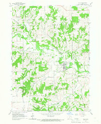
1965 Map of Arlington
USGS Topo · Published 1966About this map
Arlington sits at the northern edge of this survey, where the Chicago Milwaukee St Paul and Pacific railroad cuts across the agricultural landscape of Fairfield and Smithfield townships. The mid-1960s rural character of the area is defined by a dense network of country roads connecting isolated farmsteads with local landmarks like Maryville and the Starmont Sch in Putnam township. The terrain is deeply inscribed by the winding paths of the Maquoketa River and the South Fork Maquoketa River, which draw prominent drainage patterns through the southern half of the quadrangle.
Find a feature on this map
18 named features on this map. Tap any name to fly to it.
Don’t see what you’re looking for? This feature index may not catch every label — zoom into the map to look around manually.
Map Details
Editions of this 1965 Arlington Map
This is the sole edition of this map. No revisions or reprints were ever made.
Other maps of this area

1901 · Oelwein
USGS Topo · 1:125,000

1959 · Dubuque
USGS Topo · 1:250,000

1961 · Dubuque
USGS Topo · 1:250,000

1962 · Dubuque
USGS Topo · 1:250,000

1965 · Wadena
USGS Topo · 1:24,000

1965 · Strawberry Point
USGS Topo · 1:24,000
1965 · Volga
USGS Topo · 1:24,000

1965 · Lamont
USGS Topo · 1:24,000

1965 · Dundee
USGS Topo · 1:24,000

1976 · Dubuque
USGS Topo · 1:250,000