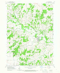
1965 Map of Volga
USGS Topo · Published 1966About this map
Volga (Volga City) serves as the primary hub along the winding Volga River in this mid-1960s survey of northeastern Iowa. The landscape is defined by the complex drainage systems of Mink Creek, Deep Creek, and Hewett Creek, which carve deep valleys and hollows into the terrain. One such prominent landform is Pilot Knob, which stands as a clear landmark amidst the agricultural fields and wooded slopes. The map reveals the rural infrastructure of the era, including a Water Tank in the main settlement and several extractive sites like a Gravel Pit and various Quarry locations. Local topography is further marked by colorfully named depressions such as German Hollow and Hells Hollow. To the south, the small community of Thomasville sits near Ensign Creek, illustrating the dispersed settlement pattern characteristic of Fairfield and Sperry townships.
Find a feature on this map
23 named features on this map. Tap any name to fly to it.
Don’t see what you’re looking for? This feature index may not catch every label — zoom into the map to look around manually.
Map Details
Editions of this 1965 Volga Map
This is the sole edition of this map. No revisions or reprints were ever made.
Other maps of this area

1901 · Oelwein
USGS Topo · 1:125,000

1902 · Elkader
USGS Topo · 1:125,000

1959 · Dubuque
USGS Topo · 1:250,000

1961 · Dubuque
USGS Topo · 1:250,000

1962 · Dubuque
USGS Topo · 1:250,000

1964 · Edgewood
USGS Topo · 1:24,000
1964 · Elkader
USGS Topo · 1:24,000
1965 · Saint Olaf
USGS Topo · 1:24,000

1965 · Elgin
USGS Topo · 1:24,000

1965 · Wadena
USGS Topo · 1:24,000