
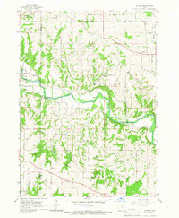
1965 Map of Elgin
USGS Topo · Published 1966About this map
The Turkey River valley dominates this mid-1960s Iowa landscape, where the settlements of Clermont and Elgin serve as focal points for the surrounding townships. The route of the Chicago Rock Island and Pacific railroad traces the river's winding path through Pleasant Valley, connecting smaller locales like Brainard and the rural crossroads of Illyria. The topography is defined by significant drainage systems including Otter Creek, Beaver Creek, and Mink Creek, which cut through the uplands to meet the Turkey River.
Find a feature on this map
30 named features on this map. Tap any name to fly to it.
Don’t see what you’re looking for? This feature index may not catch every label — zoom into the map to look around manually.
Map Details
Editions of this 1965 Elgin Map
This is the sole edition of this map. No revisions or reprints were ever made.
Other maps of this area

1901 · Oelwein
USGS Topo · 1:125,000

1906 · Decorah
USGS Topo · 1:125,000

1958 · La Crosse
USGS Topo · 1:250,000

1959 · Dubuque
USGS Topo · 1:250,000

1961 · Dubuque
USGS Topo · 1:250,000

1961 · La Crosse
USGS Topo · 1:250,000

1962 · Dubuque
USGS Topo · 1:250,000

1965 · La Crosse
USGS Topo · 1:250,000

1965 · Wadena
USGS Topo · 1:24,000
1965 · Gunder
USGS Topo · 1:24,000