1960s Maps of Buena Vista County, Iowa
Explore 2 historic maps of Buena Vista County from the 1960s. These maps offer a rare glimpse into what life looked like during the 1960s — showing old roads, neighborhoods, homes, and landmarks that have changed or disappeared over time.
Whether you're researching your family's past, planning a metal detecting trip, or studying how Buena Vista County's landscape evolved across the 1960s, these high-resolution maps are a powerful tool for exploring the history of this region.
- Focus on a specific era: All maps on this page are from the 1960s, giving you a focused view of this time period.
- See what’s changed: Compare century-old streets, trails, and buildings to today's modern landscape using overlays and satellite layers.
- Research with precision: Use these maps for genealogy, historical research, land use analysis, or educational projects.
- View, download, or print: Maps are fully viewable online in high resolution, and can be downloaded or printed for your own records.
Start exploring Buena Vista County's history through authentic maps from the 1960s. This is your window into the past.
Buena Vista County, IA maps
(2)- 1969 Map of Aurelia, 1971 Print
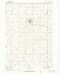 1969 Aurelia1971 Print · USGSAurelia and its surrounding townships are captured in the late sixties as a thriving rail-centered agricultural community. Researchers can trace family sites near Pleasant Hill Cem, follow the Illinois Central line, or locate the Campground Larson Lake County Park.
 - 1969 Map of Galva, 1971 Print
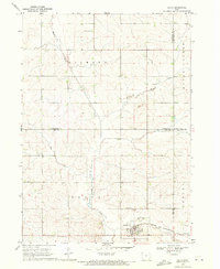 1969 Galva1971 Print · USGSAgricultural life in Ida County centered on Galva during the late sixties, where the railroad and river valleys shaped the local landscape. Genealogists and researchers can locate family plots at Diamond Cem or trace the course of the Chicago and North Western line.
End of results
Showing maps 1-2 of 2
Top cities of Buena Vista County
- Storm Lake historical maps
- Alta historical maps
- Newell historical maps
- Sioux Rapids historical maps
- Lakeside historical maps
- Albert City historical maps
See more
Frequently asked questions
- What are the different types of historical maps available for Buena Vista County?
- What is the oldest map of Buena Vista County?
- Where can I purchase historical maps of Buena Vista County for my home or office?
- Where can I download high-res historical maps of Buena Vista County?
- Are there historical topographic maps available for Buena Vista County?
- Is there historical aerial imagery available for Buena Vista County?
- Where are historical maps of Buena Vista County sourced from?