1900s (20th Century) Maps of Spencer, Iowa
Explore 7 historic maps of Spencer from the 1900s (20th Century). These maps offer a rare glimpse into what life looked like during the 1900s — showing old roads, neighborhoods, homes, and landmarks that have changed or disappeared over time.
Whether you're researching your family's past, planning a metal detecting trip, or studying how Spencer's landscape evolved across the 1900s, these high-resolution maps are a powerful tool for exploring the history of this region.
- Focus on a specific era: All maps on this page are from the 1900s, giving you a focused view of this time period.
- See what’s changed: Compare century-old streets, trails, and buildings to today's modern landscape using overlays and satellite layers.
- Research with precision: Use these maps for genealogy, historical research, land use analysis, or educational projects.
- View, download, or print: Maps are fully viewable online in high resolution, and can be downloaded or printed for your own records.
Start exploring Spencer's history through authentic maps from the 1900s. This is your window into the past.
Spencer, IA maps
(7)- 1954 Map of Fairmont, 1967 Print
 1954 Fairmont1967 Print · USGSThe prairie landscape of southern Minnesota and northern Iowa comes alive in this mid-century survey of the Coteau des Prairies. Genealogists and historians can trace the rail-connected growth of Fairmont and Blue Earth or locate family roots near St Kilian Ch and Union Slough National Wildlife Refuge.3 unique versions available
 - 1958 Map of Fairmont
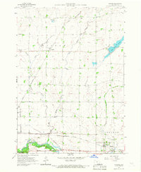
 1958 Fairmont1958 Print · USGSThe borderlands of southern Minnesota and northern Iowa come alive in the mid-1950s, showing a landscape defined by glacial lakes and rail-line commerce. Researchers can trace historic landmarks like Lakeside Laboratory, Gridley Station, and the Bancroft Wildlife Refuge across the prairie.
 - 1966 Map of Spencer, 1967 Print
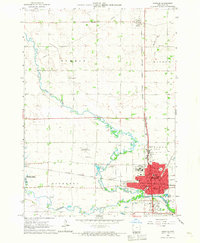 1966 Spencer1967 Print · USGSSpencer and the surrounding Clay County prairies thrived as a rail and river hub in the mid-1960s. Genealogists and local historians can trace legacy sites like Riverside Cemetery, local schools such as North School, and landmarks including the County Fairground.2 unique versions available
 - 1966 Map of Gillett Grove, 1967 Print
 1966 Gillett Grove1967 Print · USGSClay County's rural landscape is captured here in the mid-1960s as the river-and-rail economy centered on Gillett Grove remained in full swing. Researchers can trace the Chicago Milwaukee St Paul and Pacific railroad line or find the Rose Hill Cem.
 - 1966 Map of Greenville, 1967 Print
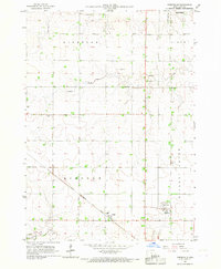 1966 Greenville1967 Print · USGSClay County's rural landscape is captured here in the mid-sixties, dominated by the diagonal path of the Chicago Rock Island and Pacific railroad. Genealogists can locate family sites at Lincoln Cem and Lutheran Cem or trace the early plats of Rossie and Greenville.
 - 1966 Map of Dickens, 1967 Print
 1966 Dickens1967 Print · USGSClay County's rural townships and rail corridors are preserved here as they appeared in the mid-1960s. Genealogists and local historians can trace the foundations of Dickens and Langdon or locate landmarks like Fairview Cem and Kingdom Hall.
 - 1985 Map of Iowa Great Lakes
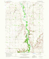
 1985 Iowa Great Lakes1985 Print · USGSNorthwest Iowa’s glacial lakes and prairie towns are captured here in the mid-1980s, showing a landscape balanced between agriculture and lakeside recreation. Genealogists and historians can locate family sites near Holman Cem or trace the early rail corridors of the Chicago and North Western and the Chicago Milwaukee St Paul and Pacific.2 unique versions available
End of results
Showing maps 1-7 of 7
Top cities near Spencer
- Milford historical maps
- Arnolds Park historical maps
- Okoboji historical maps
- Everly historical maps
- Royal historical maps
- Wahpeton historical maps
See more
Top neighborhoods of Spencer
Frequently asked questions
- What are the different types of historical maps available for Spencer?
- What is the oldest map of Spencer?
- Where can I purchase historical maps of Spencer for my home or office?
- Where can I download high-res historical maps of Spencer?
- Are there historical topographic maps available for Spencer?
- Is there historical aerial imagery available for Spencer?
- Where are historical maps of Spencer sourced from?