1990s Maps of Camanche, Iowa
Explore 2 historic maps of Camanche from the 1990s. These maps offer a rare glimpse into what life looked like during the 1990s — showing old roads, neighborhoods, homes, and landmarks that have changed or disappeared over time.
Whether you're researching your family's past, planning a metal detecting trip, or studying how Camanche's landscape evolved across the 1990s, these high-resolution maps are a powerful tool for exploring the history of this region.
- Focus on a specific era: All maps on this page are from the 1990s, giving you a focused view of this time period.
- See what’s changed: Compare century-old streets, trails, and buildings to today's modern landscape using overlays and satellite layers.
- Research with precision: Use these maps for genealogy, historical research, land use analysis, or educational projects.
- View, download, or print: Maps are fully viewable online in high resolution, and can be downloaded or printed for your own records.
Start exploring Camanche's history through authentic maps from the 1990s. This is your window into the past.
Camanche, IA maps
(2)- 1991 Map of Clinton, 1992 Print
 1991 Clinton1992 Print · USGSThe Mississippi River corridor comes alive in the early nineties, showcasing the riverfront growth of Iowa and Illinois. Genealogists can trace local roots through Clinton Mem Cem, St Patrick Ch, and school sites like Unity Christian High Sch.
 - 1991 Map of Camanche, 1992 Print
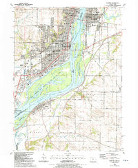
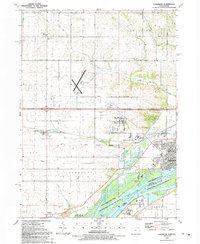 1991 Camanche1992 Print · USGSCamanche and the Clinton County riverfront are captured here in the early nineties, showcasing a region defined by the Mississippi and its surrounding townships. Genealogists can trace family sites at Pleasant Hill Cem or the settlement of Low Moor near the Chicago and North Western rail line.
End of results
Showing maps 1-2 of 2
Top cities near Camanche
- Davenport historical maps
- Bettendorf historical maps
- Clinton historical maps
- Le Claire historical maps
- Fulton historical maps
- Hampton historical maps
See more
Top neighborhoods of Camanche
Frequently asked questions
- What are the different types of historical maps available for Camanche?
- What is the oldest map of Camanche?
- Where can I purchase historical maps of Camanche for my home or office?
- Where can I download high-res historical maps of Camanche?
- Are there historical topographic maps available for Camanche?
- Is there historical aerial imagery available for Camanche?
- Where are historical maps of Camanche sourced from?