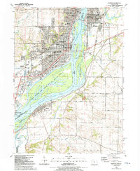
1991 Map of Clinton
USGS Topo · Published 1992About this map
The Mississippi River serves as the central artery for this riverfront landscape, defining the border between Iowa and Illinois. In the early 1990s, the urban center of Clinton shows a dense grid of neighborhoods supported by numerous institutions, including Washington High Sch and Mater Dei High Sch. Across the water, the Illinois side features the town of Fulton and the smaller settlement of Little Oklahoma, separated from the main channel by Cattail Slough. The vast Upper Mississippi River National Wild Life and Fish Refuge dominates the river valley, encompassing islands like Willow Island and Little Rock Island. This geography illustrates the complex relationship between industrial development, evidenced by the Chicago and North Western railroad lines, and the preserved wetlands of the Beaver Slough area.
Find a feature on this map
73 named features on this map. Tap any name to fly to it.
Don’t see what you’re looking for? This feature index may not catch every label — zoom into the map to look around manually.
Map Details
Editions of this 1991 Clinton Map
This is the sole edition of this map. No revisions or reprints were ever made.
Other maps of this area

1891 · Clinton
USGS Topo · 1:62,500

1892 · Goose Lake
USGS Topo · 1:62,500

1892 · Leclaire
USGS Topo · 1:62,500

1893 · Leclaire
USGS Topo · 1:62,500

1894 · Goose Lake
USGS Topo · 1:62,500

1894 · Clinton
USGS Topo · 1:62,500

1899 · Clinton
USGS Topo · 1:125,000

1952 · Erie
USGS Topo · 1:62,500

1952 · Clinton
USGS Topo · 1:62,500
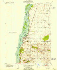
1952 · Cordova
USGS Topo · 1:24,000