1960s Maps of Davis County, Iowa
Explore 6 historic maps of Davis County from the 1960s. These maps offer a rare glimpse into what life looked like during the 1960s — showing old roads, neighborhoods, homes, and landmarks that have changed or disappeared over time.
Whether you're researching your family's past, planning a metal detecting trip, or studying how Davis County's landscape evolved across the 1960s, these high-resolution maps are a powerful tool for exploring the history of this region.
- Focus on a specific era: All maps on this page are from the 1960s, giving you a focused view of this time period.
- See what’s changed: Compare century-old streets, trails, and buildings to today's modern landscape using overlays and satellite layers.
- Research with precision: Use these maps for genealogy, historical research, land use analysis, or educational projects.
- View, download, or print: Maps are fully viewable online in high resolution, and can be downloaded or printed for your own records.
Start exploring Davis County's history through authentic maps from the 1960s. This is your window into the past.
Davis County, IA maps
(6)- 1965 Map of Eldon, 1966 Print
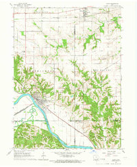 1965 Eldon1966 Print · USGSSoutheast Iowa in the mid-sixties reveals a landscape shaped by the Des Moines River and a complex network of rail lines. Researchers can locate family sites at Gontermand Cem, trace the Old Railroad Grade, or explore the riverfront at Eldon.
 - 1965 Map of Selma, 1966 Print
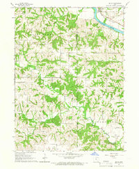 1965 Selma1966 Print · USGSSoutheast Iowa's rural townships are documented here during the mid-sixties, centered on the Selma riverfront and the surrounding family farms. Researchers can trace ancestral roots through dozens of local landmarks like Bethlehem Ch, Valley Sch, and Troy Cem.
 - 1968 Map of Blakesburg NE, 1971 Print
 1968 Blakesburg NE1971 Print · USGSSoutheast Iowa's rural townships in the late sixties remain centered around small parish churches and meandering creek beds. Trace local family history through the Jay Cem and Hopewell Cem, or follow the Milwaukee Road rail line.
 - 1968 Map of Unionville, 1971 Print
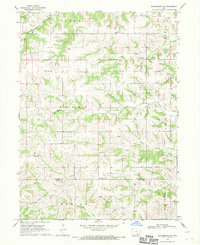
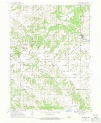
 1968 Unionville1971 Print · USGSAppanoose and Davis counties are captured in the late sixties as a landscape of rural townships and rail corridors. Researchers can trace the legacy of local families at Eaton Cem and Taylor Cem or follow the route of the Old Railroad Grade.
 - 1968 Map of Blakesburg, 1971 Print
 1968 Blakesburg1971 Print · USGSSouthern Iowa farm country and the town of Blakesburg appear here in the late sixties at a rare juncture of four counties. Genealogists can trace family names through rural landmarks like Eslinger Cem, Trussell Cem, and the Union Chapel school and church area.2 unique versions available
 - 1968 Map of Paris, 1971 Print
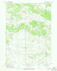
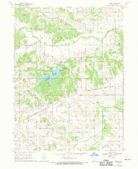 1968 Paris1971 Print · USGSDavis County's rural landscape is captured here in the late sixties, centered on the newly developed recreation areas around Wapello Lake. Researchers can trace old family roots at Paris Cem, Glassburner Cem, or Wesley Chapel Cem.
End of results
Showing maps 1-6 of 6
Top cities of Davis County
Frequently asked questions
- What are the different types of historical maps available for Davis County?
- What is the oldest map of Davis County?
- Where can I purchase historical maps of Davis County for my home or office?
- Where can I download high-res historical maps of Davis County?
- Are there historical topographic maps available for Davis County?
- Is there historical aerial imagery available for Davis County?
- Where are historical maps of Davis County sourced from?