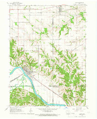
1965 Map of Eldon
USGS Topo · Published 1966About this map
The Des Moines River cuts a prominent path through this mid-1960s landscape, anchoring the city of Eldon. This riverfront hub is clearly defined by its industrial and social infrastructure, featuring the Fairground, a Waterworks, and a Water Tank near the tracks. The town serves as a junction for the Chicago Rock Island and Pacific railroad, which follows the river's curve. Further north, the Chicago Burlington and Quincy line passes through Batavia, while an Old Railroad Grade remains visible near Stoddard Cr.
Find a feature on this map
35 named features on this map. Tap any name to fly to it.
Don’t see what you’re looking for? This feature index may not catch every label — zoom into the map to look around manually.
Map Details
Editions of this 1965 Eldon Map
This is the sole edition of this map. No revisions or reprints were ever made.
Other maps of this area

1954 · Centerville
USGS Topo · 1:250,000

1954 · Des Moines
USGS Topo · 1:250,000

1956 · Des Moines
USGS Topo · 1:250,000

1956 · Farson
USGS Topo · 1:24,000

1956 · Agency
USGS Topo · 1:24,000

1956 · Ottumwa North
USGS Topo · 1:62,500

1956 · Ottumwa South
USGS Topo · 1:62,500

1957 · Des Moines
USGS Topo · 1:250,000

1957 · Centerville
USGS Topo · 1:250,000

1958 · Centerville
USGS Topo · 1:250,000