1960s Maps of Decatur County, Iowa
Explore 8 historic maps of Decatur County from the 1960s. These maps offer a rare glimpse into what life looked like during the 1960s — showing old roads, neighborhoods, homes, and landmarks that have changed or disappeared over time.
Whether you're researching your family's past, planning a metal detecting trip, or studying how Decatur County's landscape evolved across the 1960s, these high-resolution maps are a powerful tool for exploring the history of this region.
- Focus on a specific era: All maps on this page are from the 1960s, giving you a focused view of this time period.
- See what’s changed: Compare century-old streets, trails, and buildings to today's modern landscape using overlays and satellite layers.
- Research with precision: Use these maps for genealogy, historical research, land use analysis, or educational projects.
- View, download, or print: Maps are fully viewable online in high resolution, and can be downloaded or printed for your own records.
Start exploring Decatur County's history through authentic maps from the 1960s. This is your window into the past.
Decatur County, IA maps
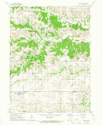
(8)- 1964 Map of Woodland, 1965 Print
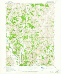 1964 Woodland1965 Print · USGSThe rural landscape of Decatur and Wayne Counties is captured in the mid-1960s, showing a well-established network of farms and country roads. Genealogists can locate several family-named burial sites like Gollough Cem and Corder Cem or the local Spring Branch Ch.
 - 1964 Map of Pleasanton, 1965 Print
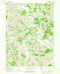 1964 Pleasanton1965 Print · USGSThe borderlands of Iowa and Missouri come to life in the mid-sixties, centered on the village of Pleasanton. Genealogists can trace family roots through several rural landmarks, including Freedom Ch, South Cem, and the small settlement of Marks.
 - 1964 Map of Leon, 1966 Print
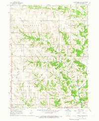
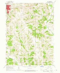 1964 Leon1966 Print · USGSLeon and the rolling farmland of Decatur County are captured here in the mid-sixties, showing the intersection of rail and river life. Researchers can locate the C B & Q rail line and several rural landmarks including St Marys Cem and the New Salem Ch.
 - 1964 Map of Lineville, 1966 Print
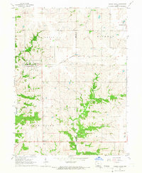
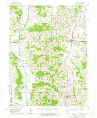 1964 Lineville1966 Print · USGSThe Iowa-Missouri border country comes to life in this mid-sixties survey of the Lineville and Mercer area. Trace family history through numerous rural cemeteries like Evergreen Cemetery and White Oak Cem, or follow the Chicago Rock Island and Pacific rail line.
 - 1965 Map of Weldon, 1966 Print
 1965 Weldon1966 Print · USGSSouthern Clarke County at the mid-century reveals an agrarian landscape centered on the settlement of Weldon. Researchers can trace the Old Railroad Grade and locate family burial sites such as Hebron Cem and Metier Cem.
 - 1965 Map of Garden Grove SW, 1966 Print
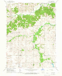
 1965 Garden Grove SW1966 Print · USGSDecatur County's rural townships are captured in the mid-1960s as a landscape of interconnected creek valleys and family farmsteads. Researchers can locate ancestral landmarks like Winters Cem, the Franklin Ch, and the original route of the Chicago Burlington and Quincy railroad.
 - 1965 Map of Le Roy, 1966 Print
 1965 Le Roy1966 Print · USGSSouthern Iowa's rural landscape at the crossroads of four counties is captured here in the mid-1960s. Researchers can trace the path of the Old Railroad Grade or find family sites like Smyrna Cem and the settlement of Last Chance.
 - 1965 Map of Garden Grove, 1967 Print
 1965 Garden Grove1967 Print · USGSDecatur and Wayne Counties are captured in the mid-1960s, showing the agricultural rhythm of southern Iowa before modernization reshaped its rural landscape. Researchers can trace family roots at Green Bay Cem. or locate regional landmarks like the Chicago Burlington and Quincy railroad and the local Drive-in Theater.
End of results
Showing maps 1-8 of 8
Top cities of Decatur County
- Lamoni historical maps
- Leon historical maps
- Grand River historical maps
- Davis City historical maps
- Van Wert historical maps
- Decatur historical maps
See more
Frequently asked questions
- What are the different types of historical maps available for Decatur County?
- What is the oldest map of Decatur County?
- Where can I purchase historical maps of Decatur County for my home or office?
- Where can I download high-res historical maps of Decatur County?
- Are there historical topographic maps available for Decatur County?
- Is there historical aerial imagery available for Decatur County?
- Where are historical maps of Decatur County sourced from?