1940s Maps of Leon, Iowa
Explore 2 historic maps of Leon from the 1940s. These maps offer a rare glimpse into what life looked like during the 1940s — showing old roads, neighborhoods, homes, and landmarks that have changed or disappeared over time.
Whether you're researching your family's past, planning a metal detecting trip, or studying how Leon's landscape evolved across the 1940s, these high-resolution maps are a powerful tool for exploring the history of this region.
- Focus on a specific era: All maps on this page are from the 1940s, giving you a focused view of this time period.
- See what’s changed: Compare century-old streets, trails, and buildings to today's modern landscape using overlays and satellite layers.
- Research with precision: Use these maps for genealogy, historical research, land use analysis, or educational projects.
- View, download, or print: Maps are fully viewable online in high resolution, and can be downloaded or printed for your own records.
Start exploring Leon's history through authentic maps from the 1940s. This is your window into the past.
Leon, IA maps
(2)- 1945 Map of Lamoni, 1957 Print
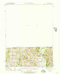 1945 Lamoni1957 Print · USGSThe Iowa and Missouri borderlands come to life in this mid-century survey of the rural corridor between Harrison and Decatur counties. Researchers can trace the tracks of the Chicago Burlington and Quincy railroad and find local landmarks like Andover, Riverview Ch, and Akron Cem.
 - 1947 Map of Lamoni
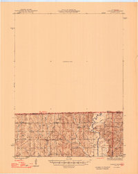 1947 Lamoni1947 Print · USGSThe rural borderlands of Iowa and Missouri are captured here just after the war, showing a dense network of country schools and churches. Genealogists can trace family roots through landmarks like Andover Cem, Lone Star Sch, and the Riverview Ch along the Thompson River.2 unique versions available
End of results
Showing maps 1-2 of 2
Top cities near Leon
- Lamoni historical maps
- Mercer historical maps
- Grand River historical maps
- Lineville historical maps
- Davis City historical maps
- Van Wert historical maps
See more
Frequently asked questions
- What are the different types of historical maps available for Leon?
- What is the oldest map of Leon?
- Where can I purchase historical maps of Leon for my home or office?
- Where can I download high-res historical maps of Leon?
- Are there historical topographic maps available for Leon?
- Is there historical aerial imagery available for Leon?
- Where are historical maps of Leon sourced from?