1960s Maps of Eddyville, Iowa
Explore 3 historic maps of Eddyville from the 1960s. These maps offer a rare glimpse into what life looked like during the 1960s — showing old roads, neighborhoods, homes, and landmarks that have changed or disappeared over time.
Whether you're researching your family's past, planning a metal detecting trip, or studying how Eddyville's landscape evolved across the 1960s, these high-resolution maps are a powerful tool for exploring the history of this region.
- Focus on a specific era: All maps on this page are from the 1960s, giving you a focused view of this time period.
- See what’s changed: Compare century-old streets, trails, and buildings to today's modern landscape using overlays and satellite layers.
- Research with precision: Use these maps for genealogy, historical research, land use analysis, or educational projects.
- View, download, or print: Maps are fully viewable online in high resolution, and can be downloaded or printed for your own records.
Start exploring Eddyville's history through authentic maps from the 1960s. This is your window into the past.
Eddyville, IA maps
(3)- 1968 Map of Kirkville, 1971 Print
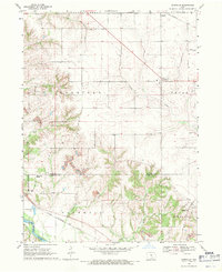 1968 Kirkville1971 Print · USGSSoutheast Iowa's coal and gravel country comes into focus in the late sixties as industrial mining reshapes the Mahaska and Wapello County line. Researchers can trace the rail sidings of the Chicago and North Western or locate Westview Cemetery and the Eddyville School.
 - 1968 Map of Eddyville, 1971 Print
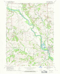 1968 Eddyville1971 Print · USGSThe Des Moines River valley in the late sixties reveals a landscape shaped by coal mining and heavy rail. Genealogists and researchers can trace local history through the streets of Eddyville, several rural cemeteries like Henness Cem, and the path of the Pacific railroad.
 - 1969 Map of Des Moines
 1969 Des Moines1969 Print · USGSCentral Iowa's fertile plains and growing capital are captured here during the late sixties, a time of major highway expansion and reservoir construction. Genealogists and researchers can trace rural township boundaries, local cemeteries, and rail lines serving towns like Pella, Grinnell, and Oskaloosa.
End of results
Showing maps 1-3 of 3
Top cities near Eddyville
- Ottumwa historical maps
- Oskaloosa historical maps
- Albia historical maps
- Fremont historical maps
- University Park historical maps
- Beacon historical maps
See more
Frequently asked questions
- What are the different types of historical maps available for Eddyville?
- What is the oldest map of Eddyville?
- Where can I purchase historical maps of Eddyville for my home or office?
- Where can I download high-res historical maps of Eddyville?
- Are there historical topographic maps available for Eddyville?
- Is there historical aerial imagery available for Eddyville?
- Where are historical maps of Eddyville sourced from?