
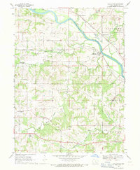
1968 Map of Kirkville
USGS Topo · Published 1971About this map
Kirkville and the surrounding farmland of Richland township appear here during a period of industrial and agricultural activity in the late 1960s. The landscape is defined by the sharp contrast between the structured grid of the Chicago Rock Island and Pacific railroad following the Des Moines River and the irregular scars of extensive Strip Mines and Sand and Gravel Pits to the north. These mining operations sit alongside small rural hubs like Cedar and Wright, while the Eddyville School and Westview Cemetery serve as local landmarks for genealogists. The topography reveals a complex drainage system where Cedar Creek, Lost Creek, and Little Muchakinock Creek carve through the terrain, illustrating the intersection of Iowa's river-bottom resources and its mid-century transport infrastructure including the Oskaloosa Municipal Airport.
Find a feature on this map
28 named features on this map. Tap any name to fly to it.
Don’t see what you’re looking for? This feature index may not catch every label — zoom into the map to look around manually.
Map Details
Editions of this 1968 Kirkville Map
This is the sole edition of this map. No revisions or reprints were ever made.
Other maps of this area

1954 · Des Moines
USGS Topo · 1:250,000

1956 · Des Moines
USGS Topo · 1:250,000

1956 · Ottumwa North
USGS Topo · 1:62,500

1956 · Ottumwa North
USGS Topo · 1:24,000

1957 · Des Moines
USGS Topo · 1:250,000

1965 · Rose Hill
USGS Topo · 1:24,000

1968 · University Park
USGS Topo · 1:24,000

1968 · Oskaloosa
USGS Topo · 1:24,000

1968 · Eddyville
USGS Topo · 1:24,000
1968 · Chillicothe
USGS Topo · 1:24,000