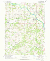
1968 Map of Chillicothe
USGS Topo · Published 1971About this map
The Des Moines River winds through this 1968 landscape, serving as a corridor for heavy industry and transportation in Wapello County. The rail network is particularly dense here, featuring lines from the Chicago Rock Island and Pacific and the Chicago Burlington and Quincy, which supported the region's extraction economy. Evidence of this activity is visible in the numerous Strip Mines and gravel pits concentrated near Kirkville Station and Chillicothe.
Find a feature on this map
37 named features on this map. Tap any name to fly to it.
Don’t see what you’re looking for? This feature index may not catch every label — zoom into the map to look around manually.
Map Details
Editions of this 1968 Chillicothe Map
This is the sole edition of this map. No revisions or reprints were ever made.
Other maps of this area

1954 · Centerville
USGS Topo · 1:250,000

1954 · Des Moines
USGS Topo · 1:250,000

1956 · Des Moines
USGS Topo · 1:250,000

1956 · Ottumwa North
USGS Topo · 1:62,500

1956 · Ottumwa South
USGS Topo · 1:24,000

1956 · Ottumwa South
USGS Topo · 1:62,500

1956 · Ottumwa North
USGS Topo · 1:24,000

1957 · Des Moines
USGS Topo · 1:250,000

1957 · Centerville
USGS Topo · 1:250,000

1958 · Centerville
USGS Topo · 1:250,000