
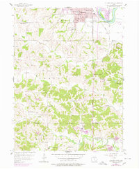
1956 Map of Ottumwa South
USGS Topo · Published 1958About this map
Ottumwa anchors the northern edge of this mid-1950s survey, where the Des Moines River bends past the Wabash railroad line. The landscape south of the city reveals a dense network of rural infrastructure, from the Drive-in Theater near the river to the scattered crossroads of Ormanville and Carbon. Educational and spiritual life is well-documented through a high concentration of country schoolhouses like Hazel Dell Sch and Hickory Flat Sch, alongside the Zion Ch and Sherman Chapel.
Find a feature on this map
42 named features on this map. Tap any name to fly to it.
Don’t see what you’re looking for? This feature index may not catch every label — zoom into the map to look around manually.
Map Details
Editions of this 1956 Ottumwa South Map
2 editions found
Other maps of this area

1954 · Centerville
USGS Topo · 1:250,000

1954 · Des Moines
USGS Topo · 1:250,000

1956 · Des Moines
USGS Topo · 1:250,000

1956 · Farson
USGS Topo · 1:24,000

1956 · Agency
USGS Topo · 1:24,000

1956 · Ottumwa North
USGS Topo · 1:62,500

1956 · Ottumwa South
USGS Topo · 1:62,500

1956 · Ottumwa North
USGS Topo · 1:24,000

1957 · Des Moines
USGS Topo · 1:250,000

1957 · Centerville
USGS Topo · 1:250,000