1960s Maps of Fayette County, Iowa
Explore 10 historic maps of Fayette County from the 1960s. These maps offer a rare glimpse into what life looked like during the 1960s — showing old roads, neighborhoods, homes, and landmarks that have changed or disappeared over time.
Whether you're researching your family's past, planning a metal detecting trip, or studying how Fayette County's landscape evolved across the 1960s, these high-resolution maps are a powerful tool for exploring the history of this region.
- Focus on a specific era: All maps on this page are from the 1960s, giving you a focused view of this time period.
- See what’s changed: Compare century-old streets, trails, and buildings to today's modern landscape using overlays and satellite layers.
- Research with precision: Use these maps for genealogy, historical research, land use analysis, or educational projects.
- View, download, or print: Maps are fully viewable online in high resolution, and can be downloaded or printed for your own records.
Start exploring Fayette County's history through authentic maps from the 1960s. This is your window into the past.
Fayette County, IA maps
(10)- 1961 Map of Dubuque
 1961 Dubuque1961 Print · USGSThe Tri-State region's river-and-rail landscape is captured here during the early sixties, showing the convergence of Iowa, Illinois, and Wisconsin. Trace mid-century rail lines like the Chicago Great Western Ry and explore sites like the Savanna Ordnance Depot and Backbone State Park.
 - 1961 Map of La Crosse
 1961 La Crosse1961 Print · USGSThe Driftless Area at the start of the 1960s reveals a complex network of river towns and rail lines along the Mississippi River. Genealogists and historians can trace old settlements like New Amsterdam and Wyattville or locate major landmarks like Camp McCoy Military Reservation and Effigy Mounds National Monument.
 - 1962 Map of Dubuque
 1962 Dubuque1962 Print · USGSThe Tri-State region's river-and-rail economy is captured here in the early sixties, centered on the Mississippi River bluffs. Genealogists and historians can locate Numerous lead and zinc mines, the New Melleray Abbey Monastery, and rural hubs like Saint Olaf.2 unique versions available
 - 1965 Map of La Crosse
 1965 La Crosse1965 Print · USGSThe Driftless Area and the Upper Mississippi valley are captured here during a period of steady mid-century growth. Researchers can trace the rail lines of the Chicago and North Western or locate riverfront sites like Effigy Mounds National Monument and the Camp McCoy Military Reservation.
 - 1965 Map of Elgin, 1966 Print
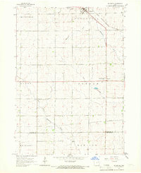
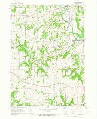 1965 Elgin1966 Print · USGSFayette County's river-valley communities come into focus during the mid-sixties as the railroad and river define the local economy. Researchers can locate family landmarks like St Peters Cem, trace the Chicago Rock Island and Pacific rail line, and find the rural outpost of Illyria.
 - 1965 Map of Wadena, 1966 Print
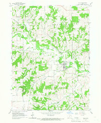
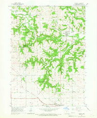 1965 Wadena1966 Print · USGSFayette County's winding river valleys are captured here in the 1960s, showing the intersection of rail transport and rural settlement. Genealogists can trace the communities of Wadena, Lima, and Taylorsville, alongside landmarks like St Josephs Cem and Brush Creek Canyon State Park.
 - 1965 Map of Gunder, 1966 Print
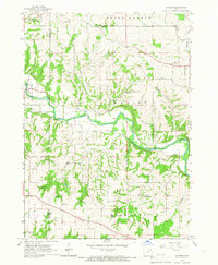 1965 Gunder1966 Print · USGSClayton and Fayette counties in the mid-sixties show a landscape of deep river valleys and high plateau farms. Researchers can trace rural life through landmarks like the East Clermont Ch, Houg Cem, and the riverside community of Elgin.
 - 1965 Map of Strawberry Point, 1966 Print
 1965 Strawberry Point1966 Print · USGSStrawberry Point and the surrounding Iowa countryside are captured here in the mid-sixties at the junction of four counties. Trace the rail-and-river landscape from the Milwaukee Road tracks to Backbone State Forest and the Fish Hatchery.
 - 1965 Map of Arlington, 1966 Print
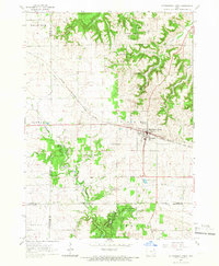
 1965 Arlington1966 Print · USGSArlington and the rolling farm country of Fayette and Buchanan counties appear here in the mid-1960s as a landscape of river-fed townships and rail. Trace the old rail lines of the Milwaukee Road and find family sites at Union Ch Cem or Maryville.
 - 1965 Map of Volga, 1966 Print
 1965 Volga1966 Print · USGSThe Volga River valley comes into focus in the mid-1960s, showing the town of Volga City and the rural community of Thomasville. Researchers can trace old township lines and local landmarks like Pilot Knob and German Hollow.
End of results
Showing maps 1-10 of 10
Top cities of Fayette County
- Oelwein historical maps
- West Union historical maps
- Fayette historical maps
- Elgin historical maps
- Clermont historical maps
- Maynard historical maps
See more
Frequently asked questions
- What are the different types of historical maps available for Fayette County?
- What is the oldest map of Fayette County?
- Where can I purchase historical maps of Fayette County for my home or office?
- Where can I download high-res historical maps of Fayette County?
- Are there historical topographic maps available for Fayette County?
- Is there historical aerial imagery available for Fayette County?
- Where are historical maps of Fayette County sourced from?