1980s Maps of Fayette County, Iowa
Explore 14 historic maps of Fayette County from the 1980s. These maps offer a rare glimpse into what life looked like during the 1980s — showing old roads, neighborhoods, homes, and landmarks that have changed or disappeared over time.
Whether you're researching your family's past, planning a metal detecting trip, or studying how Fayette County's landscape evolved across the 1980s, these high-resolution maps are a powerful tool for exploring the history of this region.
- Focus on a specific era: All maps on this page are from the 1980s, giving you a focused view of this time period.
- See what’s changed: Compare century-old streets, trails, and buildings to today's modern landscape using overlays and satellite layers.
- Research with precision: Use these maps for genealogy, historical research, land use analysis, or educational projects.
- View, download, or print: Maps are fully viewable online in high resolution, and can be downloaded or printed for your own records.
Start exploring Fayette County's history through authentic maps from the 1980s. This is your window into the past.
Fayette County, IA maps
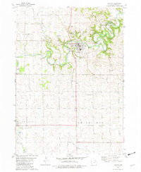
(14)- 1981 Map of Stanley, 1982 Print
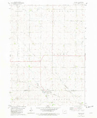 1981 Stanley1982 Print · USGSThe rural borderlands of Buchanan and Fayette Counties are captured here in the early eighties, centered on the village of Stanley. Local historians can trace family roots through the Stanley Cem, Garden Prairie Ch, and the path of the Chicago and North Western railroad.
 - 1981 Map of Maynard, 1982 Print
 1981 Maynard1982 Print · USGSFayette County agricultural life is captured here in the early eighties, centered on the rail-linked communities of Maynard and Westgate. Researchers can trace the Chicago and North Western line or locate family sites near Calvary Cem and Union Ch.
 - 1981 Map of Castalia, 1982 Print
 1981 Castalia1982 Print · USGSNortheast Iowa at the start of the eighties shows a landscape of deep river valleys and high prairie ridges centered on the village of Castalia. Genealogists and local historians can locate several family-named landmarks such as Nutting Cem and Bloomfield Cem along the Chicago Milwaukee St Paul and Pacific rail line.
 - 1981 Map of West Union, 1982 Print
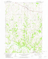
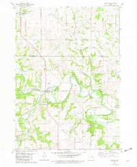
 1981 West Union1982 Print · USGSWest Union and the surrounding Fayette County townships appear here during the early eighties, a landscape of fertile farmland and river valleys. Genealogists and local historians can locate many family burial sites like South Windsor Cem or explore the geography of Echo Valley State Park and Volga Lake.
 - 1981 Map of Oelwein, 1982 Print
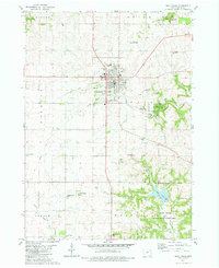
 1981 Oelwein1982 Print · USGSThe rail-centered hub of Oelwein and the rural borderlands of Fayette and Buchanan Counties are captured here in the early 1980s. Researchers can locate vanished landmarks like the Drive-in Theater or trace family plots at Woodlawn Cem and Otsego Cem.
 - 1981 Map of Hawkeye, 1982 Print
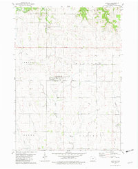 1981 Hawkeye1982 Print · USGSHawkeye and its surrounding Fayette County townships are captured here in the early eighties, showing a landscape defined by farming and small-town life. Researchers can trace ancestral sites at Oak Lawn Cem, follow the Old Railroad Grade, or locate the small settlement of Donnan.
 - 1981 Map of Festina, 1982 Print
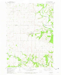
 1981 Festina1982 Print · USGSIn the early eighties, the borderlands of Winneshiek and Fayette counties remained a quiet landscape of river valleys and rural townships. Genealogists and local historians can trace legacy sites like St Marys Sch, St Peter Cem, and the riverside Eldorado.
 - 1981 Map of St. Lucas, 1982 Print
 1981 St. Lucas1982 Print · USGSThe rural border of Fayette and Winneshiek Counties comes into focus in the early eighties, centered on the village of St Lucas. Researchers can trace old family sites near Young Cem, the St Anthony of Padua Chapel, and several local quarries.
 - 1981 Map of Waucoma, 1982 Print
 1981 Waucoma1982 Print · USGSNortheast Iowa’s river-carved farmland is documented here in the early eighties at the intersection of three counties. Genealogists and local historians can trace the foundations of Waucoma, locate the Turkey Valley Community Sch, and find rural landmarks like St Johns Ch.
 - 1981 Map of Fayette, 1982 Print
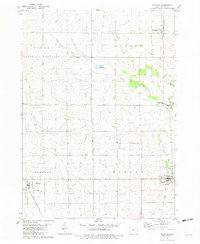
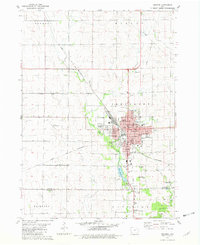
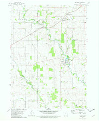
 1981 Fayette1982 Print · USGSFayette and its surrounding townships are shown here in the early eighties, centered on the campus of Upper Iowa University. Researchers can trace the Old Railroad Grade and locate family history sites such as Grandview Cem and St Francis Cem.
 - 1984 Map of Oelwein, 1985 Print
 1984 Oelwein1985 Print · USGSNortheast Iowa and the Mississippi riverfront appear in detail during the 1980s, showing a land defined by deep river valleys and high ridges. Genealogists and historians can trace the Chicago and North Western rail line and locate rural sites like St Sebald Ch and Quaker Mill Pond.2 unique versions available
 - 1984 Map of Waverly, 1985 Print
 1984 Waverly1985 Print · USGSNortheast Iowa in the mid-eighties shows a robust network of river towns and rail corridors connecting agricultural centers. Researchers can trace family sites near Garden of Memories Cem or follow the Chicago and North Western line through Janesville and Waverly.2 unique versions available
 - 1985 Map of Charles City
 1985 Charles City1985 Print · USGSNorthern Iowa and the Minnesota borderlands are mapped here in the mid-1980s as a thriving network of rail-side towns and river valleys. Trace local history through the Reilly Settlement, Stacyville Junction, and aviation sites like Ellen Church Field.2 unique versions available
 - 1985 Map of Decorah
 1985 Decorah1985 Print · USGSNortheast Iowa and western Wisconsin in the mid-eighties show a landscape of high bluffs and river valleys shaped by the Upper Iowa and Mississippi Rivers. Genealogists and historians can trace the paths of the Chicago Milwaukee St Paul and Pacific railroad or locate the National Cemetery and the ancient earthworks at Effigy Mounds National Monument.2 unique versions available
End of results
Showing maps 1-14 of 14
Top cities of Fayette County
- Oelwein historical maps
- West Union historical maps
- Fayette historical maps
- Elgin historical maps
- Clermont historical maps
- Maynard historical maps
See more
Frequently asked questions
- What are the different types of historical maps available for Fayette County?
- What is the oldest map of Fayette County?
- Where can I purchase historical maps of Fayette County for my home or office?
- Where can I download high-res historical maps of Fayette County?
- Are there historical topographic maps available for Fayette County?
- Is there historical aerial imagery available for Fayette County?
- Where are historical maps of Fayette County sourced from?