1950s Maps of Fremont County, Iowa
Explore 8 historic maps of Fremont County from the 1950s. These maps offer a rare glimpse into what life looked like during the 1950s — showing old roads, neighborhoods, homes, and landmarks that have changed or disappeared over time.
Whether you're researching your family's past, planning a metal detecting trip, or studying how Fremont County's landscape evolved across the 1950s, these high-resolution maps are a powerful tool for exploring the history of this region.
- Focus on a specific era: All maps on this page are from the 1950s, giving you a focused view of this time period.
- See what’s changed: Compare century-old streets, trails, and buildings to today's modern landscape using overlays and satellite layers.
- Research with precision: Use these maps for genealogy, historical research, land use analysis, or educational projects.
- View, download, or print: Maps are fully viewable online in high resolution, and can be downloaded or printed for your own records.
Start exploring Fremont County's history through authentic maps from the 1950s. This is your window into the past.
Fremont County, IA maps
(8)- 1955 Map of Nebraska City, 1967 Print
 1955 Nebraska City1967 Print · USGSThe four-state region surrounding the Missouri River valley appears here in the mid-1950s, a landscape of rail-dependent market towns and rural school districts. Genealogists can locate family landmarks like the Rock Bluff School, St Oswald Church, and the Clarinda State Hospital.3 unique versions available
 - 1956 Map of Rock Bluff, 1957 Print
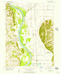 1956 Rock Bluff1957 Print · USGSThe Missouri River valley in the mid-fifties shows a landscape of river islands and bluff-side quarries. Genealogists can trace family sites at Rock Bluff and the Rock Bluff Cem, or locate rural schoolhouses like Kenosha Sch.3 unique versions available
 - 1957 Map of Nebraska City
 1957 Nebraska City1957 Print · USGSThe four-state junction of Nebraska, Iowa, Missouri, and Kansas comes alive in this mid-fifties survey of the Missouri River valley. Genealogists and historians can trace the rail-and-road networks connecting Nebraska City, Maryville, and the Squaw Creek National Wildlife Refuge.
 - 1957 Map of Randolph, 1958 Print
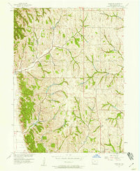
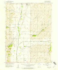 1957 Randolph1958 Print · USGSFremont County, Iowa, shows its agricultural heart and river valley infrastructure in the late fifties. Genealogists and local historians can trace the locations of the Chamber Cem and several closed country schools like Mayflower Sch (Abandoned).2 unique versions available
 - 1957 Map of Tabor, 1958 Print
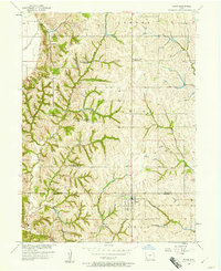 1957 Tabor1958 Print · USGSThe borderlands of Mills and Fremont counties are captured here in the late fifties as rural life shifted toward consolidation. Researchers can trace defunct schoolhouses like Elm Grove Sch and family-named burial sites including Mackey Cem.2 unique versions available
 - 1957 Map of Tabor NE, 1958 Print
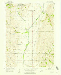 1957 Tabor NE1958 Print · USGSSouthwestern Iowa in the late 1950s was defined by its railroad arteries and shifting rural school system. Researchers can trace the WABASH rail line and identify vanished school sites like Mt Vernon Sch and Barrett Sch across the landscape.
 - 1957 Map of Tabor SW, 1958 Print
 1957 Tabor SW1958 Print · USGSFremont County's rolling hills and river bottomlands are captured here in the mid-fifties, showing the rural character of Thurman and Sidney. Local researchers can locate historic burial grounds like Acord Cem and Lacy Cem or trace the path of Plum Creek.2 unique versions available
 - 1958 Map of Nebraska City
 1958 Nebraska City1958 Print · USGSThe Missouri River Valley and its fertile four-state borderlands are captured here during the mid-century expansion of the regional highway and rail networks. Genealogists can trace family roots through numerous rural landmarks like Moulton School, Shady Grove Church, and the Clarinda State Hospital.
End of results
Showing maps 1-8 of 8
Top cities of Fremont County
- Sidney historical maps
- Tabor historical maps
- Hamburg historical maps
- Farragut historical maps
- Riverton historical maps
- Randolph historical maps
See more
Frequently asked questions
- What are the different types of historical maps available for Fremont County?
- What is the oldest map of Fremont County?
- Where can I purchase historical maps of Fremont County for my home or office?
- Where can I download high-res historical maps of Fremont County?
- Are there historical topographic maps available for Fremont County?
- Is there historical aerial imagery available for Fremont County?
- Where are historical maps of Fremont County sourced from?