1980s Maps of Fremont County, Iowa
Explore 8 historic maps of Fremont County from the 1980s. These maps offer a rare glimpse into what life looked like during the 1980s — showing old roads, neighborhoods, homes, and landmarks that have changed or disappeared over time.
Whether you're researching your family's past, planning a metal detecting trip, or studying how Fremont County's landscape evolved across the 1980s, these high-resolution maps are a powerful tool for exploring the history of this region.
- Focus on a specific era: All maps on this page are from the 1980s, giving you a focused view of this time period.
- See what’s changed: Compare century-old streets, trails, and buildings to today's modern landscape using overlays and satellite layers.
- Research with precision: Use these maps for genealogy, historical research, land use analysis, or educational projects.
- View, download, or print: Maps are fully viewable online in high resolution, and can be downloaded or printed for your own records.
Start exploring Fremont County's history through authentic maps from the 1980s. This is your window into the past.
Fremont County, IA maps
(8)- 1981 Map of Riverton
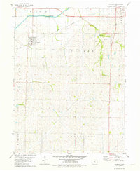
 1981 Riverton1981 Print · USGSFremont County settlement and river management are captured here in the early 1980s. Genealogists and historians can locate family burial sites like Redd Cem and Utterback Cem or trace the Old Railroad Grade through Riverton.
 - 1981 Map of Bingham
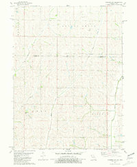
 1981 Bingham1981 Print · USGSPage County farmland in the late 1970s is centered here on the Norfolk and Western line and the valley of West Tarkio Creek. Researchers can trace old shipping routes at Norwich or locate family sites near Bingham and the Cem.
 - 1981 Map of Farragut
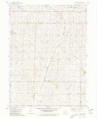
 1981 Farragut1981 Print · USGSSouthwest Iowa in the late seventies is centered on the agricultural town of Farragut and the East Nishnabotna River. Genealogists can locate family landmarks like Farragut Cemetery, Manti Cemetery, and the Summit Church.
 - 1981 Map of McElroy Creek
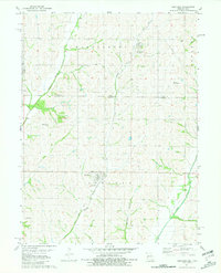
 1981 McElroy Creek1981 Print · USGSAcross the Iowa and Missouri border in the early eighties, this survey captures a landscape of family farms and rural parishes. Genealogists can locate family-named landmarks like Stoner Cem, Mt Olive Ch, and the waters of McElroy Creek.
 - 1981 Map of Farmers City
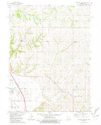
 1981 Farmers City1981 Print · USGSThe Missouri-Iowa border region comes into focus during the early eighties, showing a landscape of small townships and family farms. Researchers can trace the rural communities of Farmers City and locate local landmarks like Grange Hall Cem and St Pauls Ch.
 - 1981 Map of Westboro
 1981 Westboro1981 Print · USGSThe Iowa-Missouri borderlands are captured here in the early eighties, showcasing a rural landscape defined by the Tarkio River watershed. Researchers can trace family sites at Union Grove Cem or follow the path of the Old Railroad Grade near Northboro.
 - 1981 Map of Sidney
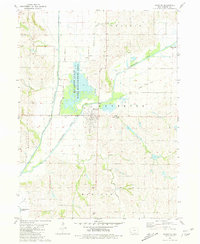
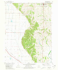 1981 Sidney1981 Print · USGSSidney and the surrounding Fremont County bluffs are shown here in the early eighties, where the steep Loess Hills meet the engineered Missouri River bottomlands. Local historians can trace family plots at Grandview Cem and Brown Cem, or explore the development of Waubonsie State Park.
 - 1985 Map of Nebraska City
 1985 Nebraska City1985 Print · USGSThe Missouri River borderlands of Nebraska, Iowa, and Missouri come into focus in the mid-1980s, showcasing a landscape of river navigation and rail-fed agriculture. Researchers can trace the heritage of Nebraska City, follow the Burlington Northern tracks, or explore river landmarks like Jones Point and McKissick Island.
End of results
Showing maps 1-8 of 8
Top cities of Fremont County
- Sidney historical maps
- Tabor historical maps
- Hamburg historical maps
- Farragut historical maps
- Riverton historical maps
- Randolph historical maps
See more
Frequently asked questions
- What are the different types of historical maps available for Fremont County?
- What is the oldest map of Fremont County?
- Where can I purchase historical maps of Fremont County for my home or office?
- Where can I download high-res historical maps of Fremont County?
- Are there historical topographic maps available for Fremont County?
- Is there historical aerial imagery available for Fremont County?
- Where are historical maps of Fremont County sourced from?