1970s Maps of Fremont County, Iowa
Explore 2 historic maps of Fremont County from the 1970s. These maps offer a rare glimpse into what life looked like during the 1970s — showing old roads, neighborhoods, homes, and landmarks that have changed or disappeared over time.
Whether you're researching your family's past, planning a metal detecting trip, or studying how Fremont County's landscape evolved across the 1970s, these high-resolution maps are a powerful tool for exploring the history of this region.
- Focus on a specific era: All maps on this page are from the 1970s, giving you a focused view of this time period.
- See what’s changed: Compare century-old streets, trails, and buildings to today's modern landscape using overlays and satellite layers.
- Research with precision: Use these maps for genealogy, historical research, land use analysis, or educational projects.
- View, download, or print: Maps are fully viewable online in high resolution, and can be downloaded or printed for your own records.
Start exploring Fremont County's history through authentic maps from the 1970s. This is your window into the past.
Fremont County, IA maps
(2)- 1978 Map of Shenandoah West
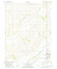 1978 Shenandoah West1978 Print · USGSShenandoah and the surrounding Iowa farmland are captured during the late seventies as the city expanded westward toward the river. Genealogists and local historians can locate the Mt Calvary Cem, Lowell Ave Sch, and the vintage Drive-in Theater.
 - 1978 Map of Imogene
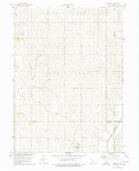 1978 Imogene1978 Print · USGSThe rural landscape of Fremont County is captured here in the late seventies, showing the rail-dependent settlement of Imogene and the surrounding farm country. Genealogists can trace family landmarks like Champion Hill Ch, the South Grove Cem, and the path of the Norfolk and Western railroad.
End of results
Showing maps 1-2 of 2
Top cities of Fremont County
- Sidney historical maps
- Tabor historical maps
- Hamburg historical maps
- Farragut historical maps
- Riverton historical maps
- Randolph historical maps
See more
Frequently asked questions
- What are the different types of historical maps available for Fremont County?
- What is the oldest map of Fremont County?
- Where can I purchase historical maps of Fremont County for my home or office?
- Where can I download high-res historical maps of Fremont County?
- Are there historical topographic maps available for Fremont County?
- Is there historical aerial imagery available for Fremont County?
- Where are historical maps of Fremont County sourced from?