1970s Maps of Iowa Falls, Iowa
Explore 3 historic maps of Iowa Falls from the 1970s. These maps offer a rare glimpse into what life looked like during the 1970s — showing old roads, neighborhoods, homes, and landmarks that have changed or disappeared over time.
Whether you're researching your family's past, planning a metal detecting trip, or studying how Iowa Falls's landscape evolved across the 1970s, these high-resolution maps are a powerful tool for exploring the history of this region.
- Focus on a specific era: All maps on this page are from the 1970s, giving you a focused view of this time period.
- See what’s changed: Compare century-old streets, trails, and buildings to today's modern landscape using overlays and satellite layers.
- Research with precision: Use these maps for genealogy, historical research, land use analysis, or educational projects.
- View, download, or print: Maps are fully viewable online in high resolution, and can be downloaded or printed for your own records.
Start exploring Iowa Falls's history through authentic maps from the 1970s. This is your window into the past.
Iowa Falls, IA maps
(3)- 1979 Map of Iowa Falls West, 1980 Print
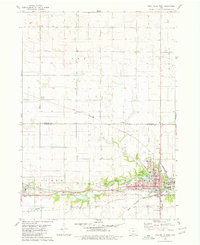 1979 Iowa Falls West1980 Print · USGSHardin and Franklin Counties are defined by the winding Iowa River and a robust rail network in the late 1970s. Researchers can trace the development of Iowa Falls, from its many schools and Ellsworth Community College to the rural Lee Center Ch.
 - 1979 Map of Buckeye East, 1980 Print
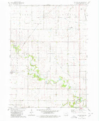 1979 Buckeye East1980 Print · USGSHardin County agriculture and rail history intersect here during the late seventies, showing the landscape before significant modern consolidation. Genealogists and local historians can trace family locations near Cottage Ch, Buckeye, and the Lincoln Cem.
 - 1979 Map of Iowa Falls East, 1980 Print
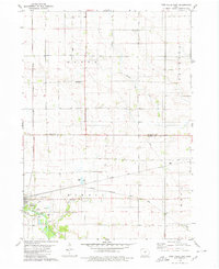 1979 Iowa Falls East1980 Print · USGSThe rail-and-river landscape of Hardin and Franklin Counties comes alive in the late 1970s as a busy agricultural hub. Researchers can trace the three major rail lines and locate family landmarks like Friends Cem, St Peters Ch, and the settlement of Robertson.
End of results
Showing maps 1-3 of 3
Top cities near Iowa Falls
- Hampton historical maps
- Eldora historical maps
- Ackley historical maps
- Hubbard historical maps
- Alden historical maps
- Radcliffe historical maps
See more
Frequently asked questions
- What are the different types of historical maps available for Iowa Falls?
- What is the oldest map of Iowa Falls?
- Where can I purchase historical maps of Iowa Falls for my home or office?
- Where can I download high-res historical maps of Iowa Falls?
- Are there historical topographic maps available for Iowa Falls?
- Is there historical aerial imagery available for Iowa Falls?
- Where are historical maps of Iowa Falls sourced from?