1950s Maps of Lee County, Iowa
Explore 3 historic maps of Lee County from the 1950s. These maps offer a rare glimpse into what life looked like during the 1950s — showing old roads, neighborhoods, homes, and landmarks that have changed or disappeared over time.
Whether you're researching your family's past, planning a metal detecting trip, or studying how Lee County's landscape evolved across the 1950s, these high-resolution maps are a powerful tool for exploring the history of this region.
- Focus on a specific era: All maps on this page are from the 1950s, giving you a focused view of this time period.
- See what’s changed: Compare century-old streets, trails, and buildings to today's modern landscape using overlays and satellite layers.
- Research with precision: Use these maps for genealogy, historical research, land use analysis, or educational projects.
- View, download, or print: Maps are fully viewable online in high resolution, and can be downloaded or printed for your own records.
Start exploring Lee County's history through authentic maps from the 1950s. This is your window into the past.
Lee County, IA maps
(3)- 1950 Map of Wayland
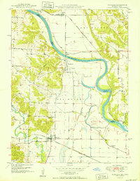 1950 Wayland1950 Print · USGSThe river border between Missouri and Iowa comes alive in the late 1940s, showing a landscape of rail-connected farming towns and river crossings. Genealogists can trace family footprints at St Francisville, Wayland, and rural landmarks like Oak Hill Cem or Independent Sch.
 - 1950 Map of Keokuk, 1954 Print
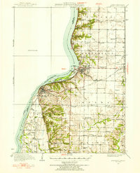 1950 Keokuk1954 Print · USGSThe Mississippi River borderlands of Iowa and Illinois come alive in the mid-century as the Keokuk Dam reshapes the valley. Genealogists can trace a remarkable concentration of local landmarks, from Moss Cem to numerous rural schoolhouses like Rocky Run Sch and Eureka Sch.
 - 1958 Map of Burlington, 1968 Print
 1958 Burlington1968 Print · USGSThe tri-state river country of Iowa, Illinois, and Missouri is captured here in the mid-fifties, dominated by the Mississippi River and major rail lines. Genealogists and historians can trace the development of river towns like Keokuk or locate the sprawling Iowa Army Ammunition Plant.4 unique versions available
End of results
Showing maps 1-3 of 3
Top cities of Lee County
- Fort Madison historical maps
- Keokuk historical maps
- West Point historical maps
- Donnellson historical maps
- Montrose historical maps
- Denmark historical maps
See more
Frequently asked questions
- What are the different types of historical maps available for Lee County?
- What is the oldest map of Lee County?
- Where can I purchase historical maps of Lee County for my home or office?
- Where can I download high-res historical maps of Lee County?
- Are there historical topographic maps available for Lee County?
- Is there historical aerial imagery available for Lee County?
- Where are historical maps of Lee County sourced from?