1970s Maps of Linn County, Iowa
Explore 11 historic maps of Linn County from the 1970s. These maps offer a rare glimpse into what life looked like during the 1970s — showing old roads, neighborhoods, homes, and landmarks that have changed or disappeared over time.
Whether you're researching your family's past, planning a metal detecting trip, or studying how Linn County's landscape evolved across the 1970s, these high-resolution maps are a powerful tool for exploring the history of this region.
- Focus on a specific era: All maps on this page are from the 1970s, giving you a focused view of this time period.
- See what’s changed: Compare century-old streets, trails, and buildings to today's modern landscape using overlays and satellite layers.
- Research with precision: Use these maps for genealogy, historical research, land use analysis, or educational projects.
- View, download, or print: Maps are fully viewable online in high resolution, and can be downloaded or printed for your own records.
Start exploring Linn County's history through authentic maps from the 1970s. This is your window into the past.
Linn County, IA maps
(11)- 1973 Map of Troy Mills, 1977 Print
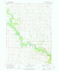 1973 Troy Mills1977 Print · USGSThe Wapsipinicon River valley in the early 1970s shows a landscape of river-bend conservation and rural crossroads. Local historians can trace the foundations of Troy Mills and find family names at St Patricks Cem, Troy Mills Cem, and Hoosier Ch.
 - 1973 Map of Prairieburg, 1977 Print
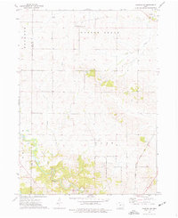
 1973 Prairieburg1977 Print · USGSEastern Iowa dairy country and river bluffs come into focus in the early seventies. You can trace the Old Railroad Grade near Prairieburg or locate family sites like St Josephs Cem and Jordans Grove.
 - 1973 Map of Springville, 1977 Print
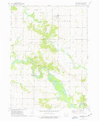
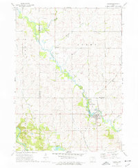
 1973 Springville1977 Print · USGSLinn County agriculture and rail life are captured in the early seventies, centered on the growing community of Springville. Genealogists and historians can trace family burial sites at St Isidore Cem and locate vanished stops along the Chicago Milwaukee St Paul and Pacific line.
 - 1973 Map of Anamosa, 1977 Print
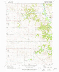
 1973 Anamosa1977 Print · USGSAnamosa and the Wapsipinicon River valley are shown here in the early 1970s, during a period defined by both institutional growth and historic limestone industry. Genealogists and local historians can locate Stone City quarries, the State Reformatory, and rural sites like Forest Chapel or Boot Hill Cem.
 - 1973 Map of Hopkinton West, 1977 Print
 1973 Hopkinton West1977 Print · USGSDelaware County and its neighboring townships come into focus during the early 1970s as the Maquoketa River valley supports a landscape of small settlements and rail. Trace family roots and land use near Hopkinton, Buck Creek, and the Grove Creek Cem.
 - 1973 Map of Ryan, 1977 Print
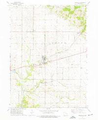
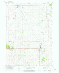
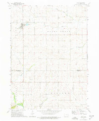 1973 Ryan1977 Print · USGSThe rural town of Ryan and its surrounding townships are shown here in the early 1970s as the rail and road networks shaped local commerce. Genealogists can trace family landmarks like Golden Ch, Nugents Grove Cem, and the LeClere Landing Strip.
 - 1973 Map of Anamosa NE, 1977 Print
 1973 Anamosa NE1977 Print · USGSJones County's rural townships and stream valleys are captured here in the early seventies, showing a landscape shaped by rail and agriculture. Genealogists can locate family sites near SS Peter & Paul Ch, Prairie Hill Cem, and the State Penal Farm.
 - 1973 Map of Coggon, 1977 Print
 1973 Coggon1977 Print · USGSThe agricultural borderlands of Linn and Delaware counties are captured here in the early 1970s. Researchers can trace the path of the Illinois Central Gulf through Coggon or locate family sites like Spring Grove Ch and St Johns Cem.
 - 1973 Map of Walker, 1977 Print
 1973 Walker1977 Print · USGSEastern Iowa farmland is captured here in the early 1970s, spanning the border of Buchanan and Linn counties. Researchers can trace the Chicago Rock Island and Pacific rail line between Rowley and Walker, locating landmarks like Sacred Heart Cem and Spencers Grove.2 unique versions available
 - 1975 Map of Cedar Rapids North, 1976 Print
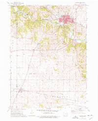
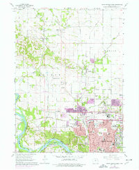 1975 Cedar Rapids North1976 Print · USGSCedar Rapids and Hiawatha show significant suburban expansion in the mid-seventies as new developments spread toward Toddville. Researchers can trace local landmarks like Mount Mercy College, Dunkard Ch, and the Chain Lakes Landing Strip during this era of growth.
 - 1976 Map of Dubuque
 1976 Dubuque1976 Print · USGSThe tri-state borderlands of Iowa, Wisconsin, and Illinois come alive during the mid-seventies, showing a region built on river commerce and mining. Genealogists and historians can trace the paths of the Illinois Central railroad or locate heritage sites like the New Melleray Abbey Monastery and Backbone State Park.
End of results
Showing maps 1-11 of 11
Top cities of Linn County
- Cedar Rapids historical maps
- Marion historical maps
- Hiawatha historical maps
- Mount Vernon historical maps
- Robins historical maps
- Fairfax historical maps
See more
Frequently asked questions
- What are the different types of historical maps available for Linn County?
- What is the oldest map of Linn County?
- Where can I purchase historical maps of Linn County for my home or office?
- Where can I download high-res historical maps of Linn County?
- Are there historical topographic maps available for Linn County?
- Is there historical aerial imagery available for Linn County?
- Where are historical maps of Linn County sourced from?