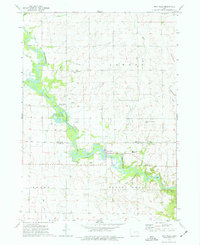
1973 Map of Troy Mills
USGS Topo · Published 1977About this map
The Wapsipinicon River meanders through the heart of this landscape, crossing the boundary between Buchanan and Linn Counties. This 1970s survey captures the community of Troy Mills as a local hub, supported by the North Linn High Sch and several surrounding cemeteries that anchor the area's family histories, including St Patricks Cem and Circle Grove Cem. The river's influence is evident in the conservation and recreation spaces along its banks, notably the Troy Mills State Fish and Game Area and Troy Mills Wapsie County Park. Away from the water, the terrain is defined by agriculture and extraction, marked by various Quarries and rural landmarks such as Hoosier Ch and the Carson Landing Strip. Smaller tributaries like Honey Creek and Dry Creek drain the surrounding townships of Cono, Newton, and Spring Grove.
Find a feature on this map
24 named features on this map. Tap any name to fly to it.
Don’t see what you’re looking for? This feature index may not catch every label — zoom into the map to look around manually.
Map Details
Editions of this 1973 Troy Mills Map
This is the sole edition of this map. No revisions or reprints were ever made.
Other maps of this area

1888 · Shellsburg
USGS Topo · 1:62,500

1888 · Marion
USGS Topo · 1:62,500

1889 · Marion
USGS Topo · 1:62,500

1889 · Shellsburg
USGS Topo · 1:62,500

1899 · Shellsburg
USGS Topo · 1:62,500

1903 · Winthrop
USGS Topo · 1:125,000

1959 · Dubuque
USGS Topo · 1:250,000

1961 · Dubuque
USGS Topo · 1:250,000

1962 · Dubuque
USGS Topo · 1:250,000
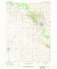
1968 · Central City
USGS Topo · 1:24,000