1990s Maps of Linn County, Iowa
Explore 9 historic maps of Linn County from the 1990s. These maps offer a rare glimpse into what life looked like during the 1990s — showing old roads, neighborhoods, homes, and landmarks that have changed or disappeared over time.
Whether you're researching your family's past, planning a metal detecting trip, or studying how Linn County's landscape evolved across the 1990s, these high-resolution maps are a powerful tool for exploring the history of this region.
- Focus on a specific era: All maps on this page are from the 1990s, giving you a focused view of this time period.
- See what’s changed: Compare century-old streets, trails, and buildings to today's modern landscape using overlays and satellite layers.
- Research with precision: Use these maps for genealogy, historical research, land use analysis, or educational projects.
- View, download, or print: Maps are fully viewable online in high resolution, and can be downloaded or printed for your own records.
Start exploring Linn County's history through authentic maps from the 1990s. This is your window into the past.
Linn County, IA maps
(9)- 1993 Map of Mount Vernon, 1994 Print
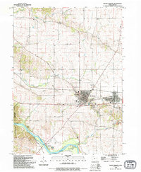 1993 Mount Vernon1994 Print · USGSMount Vernon and Lisbon are shown as established hubs during the early nineties, centered on the railroad and academia. Researchers can trace family sites at Abbe Creek Cem, explore the Cornell College campus, or locate the riverside Ivanhoe settlement.
 - 1993 Map of Fairfax, 1994 Print
 1993 Fairfax1994 Print · USGSThe rural corridor between Benton and Linn counties is captured in the early nineties, showing agricultural settlements and expanding suburban edges. Genealogists can trace family history at St Patricks Cem, Benton Sch, and the Milwaukee Road rail lines.
 - 1993 Map of Bertram, 1994 Print
 1993 Bertram1994 Print · USGSLinn County in the early nineties shows the suburban growth of Cedar Rapids reaching toward the tranquil Cedar River valley. Genealogists can trace family names and local landmarks through sites like Campbell Cem, Buresh Cem, and the historic Erskine Sch.
 - 1993 Map of Shellsburg, 1994 Print
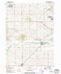
 1993 Shellsburg1994 Print · USGSThe Cedar River valley in the early nineties shows a landscape where industrial energy and conservation meet. You can trace family roots at Strawn Cem or Old Palo Cem, and locate the Duane Arnold Energy Center near the village of Palo.
 - 1994 Map of Cedar Rapids North
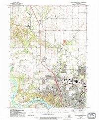 1994 Cedar Rapids North1994 Print · USGSNorthern Linn County emerges in the early nineties as suburban expansion moves toward established communities like Toddville and Robins. Researchers can trace local genealogy at Dunkard Cem, explore the Cedar Valley Nature Trail, or locate landmarks like Mcbride Airfield.2 unique versions available
 - 1994 Map of Ely
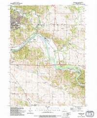
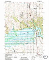
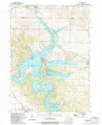 1994 Ely1994 Print · USGSThe reservoir country of Johnson and Linn counties is captured in the mid-nineties, showing the integration of water recreation and town life. Trace family roots at Sulek Cem or follow the Old Railroad Grade through Solon.
 - 1994 Map of Cedar Rapids South
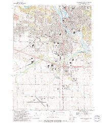 1994 Cedar Rapids South1994 Print · USGSThe southern suburbs of Cedar Rapids come into focus in the mid-nineties, showing the city's reach toward the Municipal Airport. Researchers can trace local development through landmarks like Hawkeye Downs, Westdale Mall, and numerous historic burial grounds including Linwood Cemetery.2 unique versions available
 - 1994 Map of Swisher
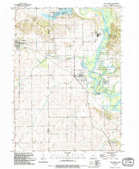
 1994 Swisher1994 Print · USGSThe Johnson County river valley and surrounding prairies are captured here in the 1990s as the landscape balances wildlife conservation and rural growth. Researchers can trace numerous family burial grounds including Anderson Cem, Dupont Cem, and Greencastle Cem near the town of Swisher.
 - 1994 Map of Marion
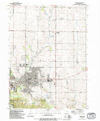 1994 Marion1994 Print · USGSMarion and the northern reaches of Cedar Rapids are captured here in the mid-nineties, showing a landscape of rapid suburban growth and established rural roots. Researchers can trace local genealogy and land use through landmarks like Oakshade Cem, the OLD RAILROAD GRADE, and schools such as Linn-Mar Sch.
End of results
Showing maps 1-9 of 9
Top cities of Linn County
- Cedar Rapids historical maps
- Marion historical maps
- Hiawatha historical maps
- Mount Vernon historical maps
- Robins historical maps
- Fairfax historical maps
See more
Frequently asked questions
- What are the different types of historical maps available for Linn County?
- What is the oldest map of Linn County?
- Where can I purchase historical maps of Linn County for my home or office?
- Where can I download high-res historical maps of Linn County?
- Are there historical topographic maps available for Linn County?
- Is there historical aerial imagery available for Linn County?
- Where are historical maps of Linn County sourced from?