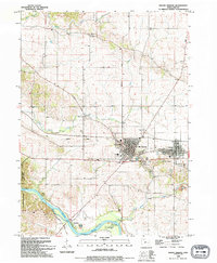
1993 Map of Mount Vernon
USGS Topo · Published 1994About this map
The Cedar River flows through the southern portion of this landscape, anchoring a series of protected lands including Palisades-Kepler State Park and South Cedar County Park. This 1993 revision reveals the dense academic and residential grid of Mt Vernon and the neighboring community of Lisbon, both situated along the C & NW RR. The presence of Cornell College and the central High Sch marks the area as a regional educational hub, while the surrounding hills are dotted with local history sites like Abbe Creek Cem and Mt Zion Ch. North of the river, the small settlement of Ivanhoe remains near a local Sandpit, connected by the historic Ivanhoe Road. The mapping of an Old Railroad Grade and several rural cemeteries provides a clear view of the area's older transportation and genealogical roots.
Find a feature on this map
38 named features on this map. Tap any name to fly to it.
Don’t see what you’re looking for? This feature index may not catch every label — zoom into the map to look around manually.
Map Details
Editions of this 1993 Mount Vernon Map
This is the sole edition of this map. No revisions or reprints were ever made.
Other maps of this area

1887 · Cedar Rapids
USGS Topo · 1:62,500

1888 · Marion
USGS Topo · 1:62,500

1889 · Marion
USGS Topo · 1:62,500

1890 · Anamosa
USGS Topo · 1:62,500

1891 · Mechanicsville
USGS Topo · 1:62,500

1891 · Cedar Rapids
USGS Topo · 1:62,500

1894 · Mechanicsville
USGS Topo · 1:62,500

1900 · Anamosa
USGS Topo · 1:125,000

1901 · Stanwood
USGS Topo · 1:125,000

1903 · Fairfax
USGS Topo · 1:125,000