1970s Maps of Allison Township, Iowa
Explore 2 historic maps of Allison Township from the 1970s. These maps offer a rare glimpse into what life looked like during the 1970s — showing old roads, neighborhoods, homes, and landmarks that have changed or disappeared over time.
Whether you're researching your family's past, planning a metal detecting trip, or studying how Allison Township's landscape evolved across the 1970s, these high-resolution maps are a powerful tool for exploring the history of this region.
- Focus on a specific era: All maps on this page are from the 1970s, giving you a focused view of this time period.
- See what’s changed: Compare century-old streets, trails, and buildings to today's modern landscape using overlays and satellite layers.
- Research with precision: Use these maps for genealogy, historical research, land use analysis, or educational projects.
- View, download, or print: Maps are fully viewable online in high resolution, and can be downloaded or printed for your own records.
Start exploring Allison Township's history through authentic maps from the 1970s. This is your window into the past.
Allison Township, IA maps
(2)- 1971 Map of Lester, 1973 Print
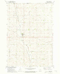 1971 Lester1973 Print · USGSLester and the surrounding northwest Iowa townships are captured here in the early 1970s, as the railroad still dictated the local economy. Genealogists and researchers can locate family sites near Hillside Cem or trace the Burlington Northern line and Mud Creek.
 - 1971 Map of Rock Rapids, 1973 Print
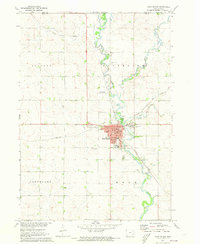 1971 Rock Rapids1973 Print · USGSNorthwest Iowa near the Minnesota border appears here as a thriving rail and river hub in the early seventies. You can trace the path of the Chicago Rock Island and Pacific railroad through Rock Rapids and locate family landmarks like Holy Name Cem or the Christian Sch.
End of results
Showing maps 1-2 of 2
Top cities near Allison Township
- Luverne historical maps
- Rock Rapids historical maps
- Inwood historical maps
- Larchwood historical maps
- Valley Springs historical maps
- Doon historical maps
See more
Frequently asked questions
- What are the different types of historical maps available for Allison Township?
- What is the oldest map of Allison Township?
- Where can I purchase historical maps of Allison Township for my home or office?
- Where can I download high-res historical maps of Allison Township?
- Are there historical topographic maps available for Allison Township?
- Is there historical aerial imagery available for Allison Township?
- Where are historical maps of Allison Township sourced from?