1910s Maps of Harvey, Clay Township
Explore 2 historic maps of Harvey from the 1910s. These maps offer a rare glimpse into what life looked like during the 1910s — showing old roads, neighborhoods, homes, and landmarks that have changed or disappeared over time.
Whether you're researching your family's past, planning a metal detecting trip, or studying how Harvey's landscape evolved across the 1910s, these high-resolution maps are a powerful tool for exploring the history of this region.
- Focus on a specific era: All maps on this page are from the 1910s, giving you a focused view of this time period.
- See what’s changed: Compare century-old streets, trails, and buildings to today's modern landscape using overlays and satellite layers.
- Research with precision: Use these maps for genealogy, historical research, land use analysis, or educational projects.
- View, download, or print: Maps are fully viewable online in high resolution, and can be downloaded or printed for your own records.
Start exploring Harvey's history through authentic maps from the 1910s. This is your window into the past.
Harvey, Clay Township maps
(2)- 1910 Map of Pella, 1958 Print
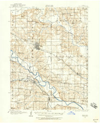 1910 Pella1958 Print · USGSMarion and Mahaska counties at the peak of the rail era show a landscape dotted with country schools and river settlements. Genealogists and historians can locate vanished schoolhouses like Bunker Hill School and trace the paths of the Chicago Rock Island and Pacific through Pella and Leighton.2 unique versions available
 - 1912 Map of Pella
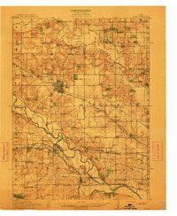 1912 Pella1912 Print · USGSThe river valleys of Marion County come alive in this pre-World War I portrait of a thriving agricultural and rail corridor. Researchers can pinpoint early homesteads near dozens of rural landmarks, including Pella, Salem Church, and the West Amsterdam School.2 unique versions available
End of results
Showing maps 1-2 of 2
Top cities near Harvey
- Pella historical maps
- Knoxville historical maps
- Monroe historical maps
- Lovilia historical maps
- Bussey historical maps
- Leighton historical maps
See more
Frequently asked questions
- What are the different types of historical maps available for Harvey?
- What is the oldest map of Harvey?
- Where can I purchase historical maps of Harvey for my home or office?
- Where can I download high-res historical maps of Harvey?
- Are there historical topographic maps available for Harvey?
- Is there historical aerial imagery available for Harvey?
- Where are historical maps of Harvey sourced from?