1980s Maps of Knoxville Township, Iowa
Explore 6 historic maps of Knoxville Township from the 1980s. These maps offer a rare glimpse into what life looked like during the 1980s — showing old roads, neighborhoods, homes, and landmarks that have changed or disappeared over time.
Whether you're researching your family's past, planning a metal detecting trip, or studying how Knoxville Township's landscape evolved across the 1980s, these high-resolution maps are a powerful tool for exploring the history of this region.
- Focus on a specific era: All maps on this page are from the 1980s, giving you a focused view of this time period.
- See what’s changed: Compare century-old streets, trails, and buildings to today's modern landscape using overlays and satellite layers.
- Research with precision: Use these maps for genealogy, historical research, land use analysis, or educational projects.
- View, download, or print: Maps are fully viewable online in high resolution, and can be downloaded or printed for your own records.
Start exploring Knoxville Township's history through authentic maps from the 1980s. This is your window into the past.
Knoxville Township, IA maps
(6)- 1980 Map of Pella
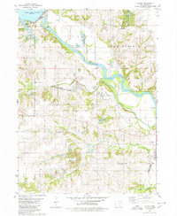
 1980 Pella1980 Print · USGSPella and the surrounding Marion County farmlands are captured in the early eighties, showcasing a landscape shaped by Dutch heritage and river geography. Genealogists and historians can trace institutional roots at the Central Univ of Iowa, locate family plots at Oak Wood Cem, or follow the Chicago Rock Island and Pacific rail line.
 - 1980 Map of Harvey
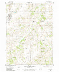
 1980 Harvey1980 Print · USGSMarion County's river valley is captured here in the late seventies, showing the rail-and-river economy near Harvey. Genealogists can trace family locations through several rural cemeteries like Eureka Cem and Brecke Ridge Cem or the small settlement of Tracy.
 - 1982 Map of Oskaloosa
 1982 Oskaloosa1982 Print · USGSSoutheast Iowa's river valleys and rail hubs are meticulously detailed in the early eighties, showing a landscape of productive farmland and growing municipal centers. Researchers can trace the legacy of small-town life and local industry through features like Union Mills, What Cheer, and the extensive Burlington Northern rail network.
 - 1982 Map of Attica, 1983 Print
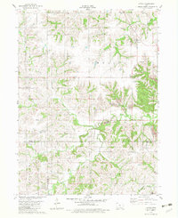 1982 Attica1983 Print · USGSThe rural landscape of Marion County in the early eighties reveals a mix of upland farming and active industrial sites. Genealogists can locate several family cemeteries such as Hogeland Cem and Oak Dale Cem, while researchers can trace local coal history through the Strip Mines near Indiana Chapel.
 - 1982 Map of Melcher, 1983 Print
 1982 Melcher1983 Print · USGSMarion County agriculture and small-town life are captured here in the early eighties as the settlements of Melcher and Dallas thrive. Local researchers can trace family landmarks like Sacred Heart Ch, Columbia Cem, and the community of Gosport.
 - 1984 Map of Indianola
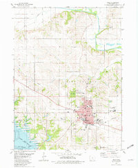
 1984 Indianola1984 Print · USGSSouth-central Iowa in the mid-1980s reveals a patchwork of established rail hubs and significant new conservation areas. Trace the Chicago and North Western rail lines and explore rural landmarks like Lake Ahquabi State Park or the Strip Mine near Knoxville.
End of results
Showing maps 1-6 of 6
Top cities near Knoxville Township
- Pella historical maps
- Knoxville historical maps
- Monroe historical maps
- Pleasantville historical maps
- Melcher-Dallas historical maps
- Lovilia historical maps
See more
Top neighborhoods of Knoxville Township
Frequently asked questions
- What are the different types of historical maps available for Knoxville Township?
- What is the oldest map of Knoxville Township?
- Where can I purchase historical maps of Knoxville Township for my home or office?
- Where can I download high-res historical maps of Knoxville Township?
- Are there historical topographic maps available for Knoxville Township?
- Is there historical aerial imagery available for Knoxville Township?
- Where are historical maps of Knoxville Township sourced from?