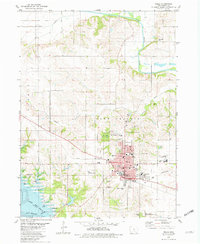
1980 Map of Pella
USGS Topo · Published 1980About this map
The Dutch-influenced city of Pella stands as a significant cultural and educational hub in this 1980 survey, dominated by the campus of the Central Univ of Iowa and several religious and educational institutions like Faith Christian Sch and the Christian High Sch. The town is framed by traditional burial grounds including Oak Wood Cem and Graceland Cem, reflecting the community's deep-rooted history. To the south and west, the landscape shifts toward the recreational and industrial margins of the Des Moines River and the expanding waters of Lake Red Rock, where a Boat Ramp and Campground indicate the area's role as a regional destination.
Find a feature on this map
40 named features on this map. Tap any name to fly to it.
Don’t see what you’re looking for? This feature index may not catch every label — zoom into the map to look around manually.
Map Details
Editions of this 1980 Pella Map
This is the sole edition of this map. No revisions or reprints were ever made.
Other maps of this area

1909 · Knoxville
USGS Topo · 1:62,500

1910 · Pella
USGS Topo · 1:62,500

1912 · Knoxville
USGS Topo · 1:62,500

1912 · Pella
USGS Topo · 1:62,500

1954 · Des Moines
USGS Topo · 1:250,000

1956 · Des Moines
USGS Topo · 1:250,000

1957 · Des Moines
USGS Topo · 1:250,000

1965 · Monroe
USGS Topo · 1:24,000
1965 · Otley
USGS Topo · 1:24,000
1965 · Knoxville
USGS Topo · 1:24,000