1970s Maps of Mitchell, Iowa
Explore 2 historic maps of Mitchell from the 1970s. These maps offer a rare glimpse into what life looked like during the 1970s — showing old roads, neighborhoods, homes, and landmarks that have changed or disappeared over time.
Whether you're researching your family's past, planning a metal detecting trip, or studying how Mitchell's landscape evolved across the 1970s, these high-resolution maps are a powerful tool for exploring the history of this region.
- Focus on a specific era: All maps on this page are from the 1970s, giving you a focused view of this time period.
- See what’s changed: Compare century-old streets, trails, and buildings to today's modern landscape using overlays and satellite layers.
- Research with precision: Use these maps for genealogy, historical research, land use analysis, or educational projects.
- View, download, or print: Maps are fully viewable online in high resolution, and can be downloaded or printed for your own records.
Start exploring Mitchell's history through authentic maps from the 1970s. This is your window into the past.
Mitchell, IA maps
(2)- 1972 Map of Osage, 1974 Print
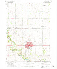 1972 Osage1974 Print · USGSMitchell County in the early seventies centers on the bustling seat of Osage and the banks of the Cedar River. Genealogists and local historians can trace the foundations of the community through Sacred Heart Church, Oak Grove Cemetery, and the Old Grade Railroad.
 - 1972 Map of Osage SW, 1974 Print
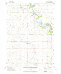 1972 Osage SW1974 Print · USGSMitchell County in the early seventies shows a landscape defined by the winding Cedar River and its rail connections. Genealogists can locate several local burial grounds including Brakestad Cem and St Johns Cem, alongside the historic settlement at St Ansgar.
End of results
Showing maps 1-2 of 2
Top cities near Mitchell
- Osage historical maps
- Nora Springs historical maps
- Saint Ansgar historical maps
- Lyle historical maps
- Stacyville historical maps
- Rudd historical maps
See more
Frequently asked questions
- What are the different types of historical maps available for Mitchell?
- What is the oldest map of Mitchell?
- Where can I purchase historical maps of Mitchell for my home or office?
- Where can I download high-res historical maps of Mitchell?
- Are there historical topographic maps available for Mitchell?
- Is there historical aerial imagery available for Mitchell?
- Where are historical maps of Mitchell sourced from?