1960s Maps of Onawa, Iowa
Explore 2 historic maps of Onawa from the 1960s. These maps offer a rare glimpse into what life looked like during the 1960s — showing old roads, neighborhoods, homes, and landmarks that have changed or disappeared over time.
Whether you're researching your family's past, planning a metal detecting trip, or studying how Onawa's landscape evolved across the 1960s, these high-resolution maps are a powerful tool for exploring the history of this region.
- Focus on a specific era: All maps on this page are from the 1960s, giving you a focused view of this time period.
- See what’s changed: Compare century-old streets, trails, and buildings to today's modern landscape using overlays and satellite layers.
- Research with precision: Use these maps for genealogy, historical research, land use analysis, or educational projects.
- View, download, or print: Maps are fully viewable online in high resolution, and can be downloaded or printed for your own records.
Start exploring Onawa's history through authentic maps from the 1960s. This is your window into the past.
Onawa, IA maps
(2)- 1969 Map of Onawa, 1971 Print
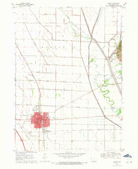 1969 Onawa1971 Print · USGSOnawa and the surrounding Monona County flatlands are shown in the late sixties as a landscape defined by industrial-scale drainage and rail transit. Genealogists and local historians can trace the town's footprint from the West Monona Sch to the Cemetery and the small siding at Kennebec.
 - 1969 Map of Onawa SW, 1971 Print
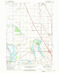 1969 Onawa SW1971 Print · USGSThe Missouri River bottoms at the close of the 1960s reveal a landscape of managed wetlands and vital river crossings. Researchers can trace the Chicago and North Western rail line near Whiting or locate Harrison Cem and Nebowa Camp.
End of results
Showing maps 1-2 of 2
Top cities near Onawa
- Sloan historical maps
- Whiting historical maps
- Decatur historical maps
- Arizona historical maps
- Hornick historical maps
- Pisgah historical maps
See more
Frequently asked questions
- What are the different types of historical maps available for Onawa?
- What is the oldest map of Onawa?
- Where can I purchase historical maps of Onawa for my home or office?
- Where can I download high-res historical maps of Onawa?
- Are there historical topographic maps available for Onawa?
- Is there historical aerial imagery available for Onawa?
- Where are historical maps of Onawa sourced from?