1970s Maps of Muscatine County, Iowa
Explore 2 historic maps of Muscatine County from the 1970s. These maps offer a rare glimpse into what life looked like during the 1970s — showing old roads, neighborhoods, homes, and landmarks that have changed or disappeared over time.
Whether you're researching your family's past, planning a metal detecting trip, or studying how Muscatine County's landscape evolved across the 1970s, these high-resolution maps are a powerful tool for exploring the history of this region.
- Focus on a specific era: All maps on this page are from the 1970s, giving you a focused view of this time period.
- See what’s changed: Compare century-old streets, trails, and buildings to today's modern landscape using overlays and satellite layers.
- Research with precision: Use these maps for genealogy, historical research, land use analysis, or educational projects.
- View, download, or print: Maps are fully viewable online in high resolution, and can be downloaded or printed for your own records.
Start exploring Muscatine County's history through authentic maps from the 1970s. This is your window into the past.
Muscatine County, IA maps
(2)- 1970 Map of Columbus Junction, 1972 Print
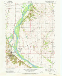 1970 Columbus Junction1972 Print · USGSLouisa and Muscatine Counties are captured here in the early 1970s at the strategic meeting of the rivers. Genealogists can trace rural roots through several local burial grounds like Newell Cem and Concord Cem or the community life at the Fairground.
 - 1970 Map of Nichols, 1972 Print
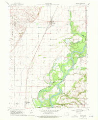 1970 Nichols1972 Print · USGSThe river and rail networks of Muscatine and Louisa counties are meticulously detailed in the early 1970s. Trace family history through numerous burial sites like Lone Tree Cem and Brockway Cem, or follow the legacy of the Chicago Rock Island and Pacific railroad through Nichols.2 unique versions available
End of results
Showing maps 1-2 of 2
Top cities of Muscatine County
- Muscatine historical maps
- West Liberty historical maps
- Wilton historical maps
- Fruitland historical maps
- Conesville historical maps
- Nichols historical maps
See more
Frequently asked questions
- What are the different types of historical maps available for Muscatine County?
- What is the oldest map of Muscatine County?
- Where can I purchase historical maps of Muscatine County for my home or office?
- Where can I download high-res historical maps of Muscatine County?
- Are there historical topographic maps available for Muscatine County?
- Is there historical aerial imagery available for Muscatine County?
- Where are historical maps of Muscatine County sourced from?