1990s Maps of Muscatine County, Iowa
Explore 7 historic maps of Muscatine County from the 1990s. These maps offer a rare glimpse into what life looked like during the 1990s — showing old roads, neighborhoods, homes, and landmarks that have changed or disappeared over time.
Whether you're researching your family's past, planning a metal detecting trip, or studying how Muscatine County's landscape evolved across the 1990s, these high-resolution maps are a powerful tool for exploring the history of this region.
- Focus on a specific era: All maps on this page are from the 1990s, giving you a focused view of this time period.
- See what’s changed: Compare century-old streets, trails, and buildings to today's modern landscape using overlays and satellite layers.
- Research with precision: Use these maps for genealogy, historical research, land use analysis, or educational projects.
- View, download, or print: Maps are fully viewable online in high resolution, and can be downloaded or printed for your own records.
Start exploring Muscatine County's history through authentic maps from the 1990s. This is your window into the past.
Muscatine County, IA maps
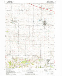
(7)- 1991 Map of Muscatine, 1992 Print
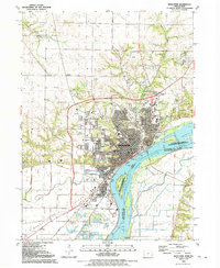 1991 Muscatine1992 Print · USGSMuscatine and the fertile riverfront of the early 1990s are captured here during a period of steady industrial and residential development. Genealogists and historians can trace neighborhood landmarks like Spangler Chapel, St Marys Cem, and the massive Greenwood Cemetery near the city center.
 - 1991 Map of Durant, 1992 Print
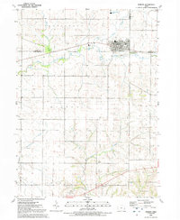 1991 Durant1992 Print · USGSEastern Iowa's borderlands near the tri-county junction of Cedar, Muscatine, and Scott are captured in the early nineties. Genealogists and local historians can trace the street grid of Durant, locate Melpine Cem, and follow the courses of Mud Creek and Big Elkhorn Creek.
 - 1991 Map of Illinois City, 1992 Print
 1991 Illinois City1992 Print · USGSThe Mississippi River islands and Iowa-Illinois borderlands are captured here in the early nineties. Genealogists can locate family sites like Ziegler Memorial Ch, Fairport Cem, and the rural community of Illinois City.2 unique versions available
 - 1991 Map of Wilton, 1992 Print
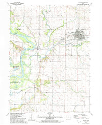 1991 Wilton1992 Print · USGSWilton and the Cedar River valley appear in the early nineties, showing a landscape defined by small towns and river floodplains. Genealogists can locate several historic burial sites like St Marys Cem and Wildsin Cem, or trace the Old Railroad Grade.
 - 1991 Map of Walcott, 1992 Print
 1991 Walcott1992 Print · USGSIowan prairie and evolving towns appear here in the early nineties as modern transit intersects with rural heritage. Genealogists and local historians can trace family ties at Parr Cem or explore the layouts of Walcott and Blue Grass.
 - 1991 Map of Blanchard Island, 1992 Print
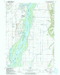 1991 Blanchard Island1992 Print · USGSThe Mississippi River valley at the start of the nineties reveals a landscape of massive flood control projects and wildlife conservation. Genealogists and historians can trace local landmarks like Reynolds Cem or the remote Carl Ritter Landing Strip among the river chutes and islands.
 - 1991 Map of Montpelier, 1992 Print
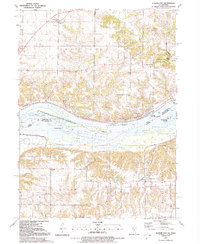
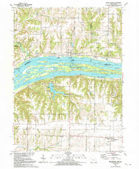 1991 Montpelier1992 Print · USGSThe Mississippi River corridor near the Iowa-Illinois border is documented here in the early nineties, showing a landscape defined by island channels and bluff-top settlements. Researchers can locate Edgington and Montpelier, or trace the grounds of Loud Thunder Camp and St Patricks Ch.
End of results
Showing maps 1-7 of 7
Top cities of Muscatine County
- Muscatine historical maps
- West Liberty historical maps
- Wilton historical maps
- Fruitland historical maps
- Conesville historical maps
- Nichols historical maps
See more
Frequently asked questions
- What are the different types of historical maps available for Muscatine County?
- What is the oldest map of Muscatine County?
- Where can I purchase historical maps of Muscatine County for my home or office?
- Where can I download high-res historical maps of Muscatine County?
- Are there historical topographic maps available for Muscatine County?
- Is there historical aerial imagery available for Muscatine County?
- Where are historical maps of Muscatine County sourced from?